


NHC Graphical Outlook Archive
|
« Earliest Available ‹ Earlier Later › Latest Available » |
| Eastern Pacific | Atlantic |
|
|
(mouse over shaded areas for details; click on shaded areas or disturbance numbers to switch views) |
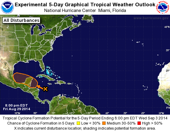
Tropical Weather Outlook Text
TROPICAL WEATHER OUTLOOK
NWS NATIONAL HURRICANE CENTER MIAMI FL
800 PM EDT FRI AUG 29 2014

For the North Atlantic...Caribbean Sea and the Gulf of Mexico:

1. A large area of disorganized cloudiness and thunderstorms is
associated with a tropical wave located in the central Caribbean
Sea. Upper-level winds are forecast to become a little more
favorable for development on Saturday while the wave moves into the
northwestern Caribbean Sea. However, land interaction will likely
limit significant development as the disturbance moves across the
Yucatan peninsula on Sunday. Environmental conditions are expected
to be conducive for some gradual development once the system moves
into the southwestern Gulf of Mexico by Monday.
* Formation chance through 48 hours...low...10 percent.
* Formation chance through 5 days...medium...30 percent.

Forecaster Brennan
List of Atlantic Outlooks (May 2023 - present)
List of East Pacific Outlooks (May 2023 - present)
List of Central Pacific Outlooks (May 2023 - present)
List of Atlantic Outlooks (July 2014 - April 2023)
List of East Pacific Outlooks (July 2014 - April 2023)
List of Central Pacific Outlooks (June 2019 - April 2023)
List of Atlantic Outlooks (June 2009 - June 2014)
List of East Pacific Outlooks (June 2009 - June 2014)