


NHC Graphical Outlook Archive
|
« Earliest Available ‹ Earlier Later › Latest Available » |
| Eastern Pacific | Atlantic |
|
|
(mouse over shaded areas for details; click on shaded areas or disturbance numbers to switch views) |
Tropical Weather Outlook Text
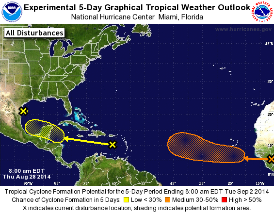
TROPICAL WEATHER OUTLOOK
NWS NATIONAL HURRICANE CENTER MIAMI FL
800 AM EDT THU AUG 28 2014

For the North Atlantic...Caribbean Sea and the Gulf of Mexico:

The National Hurricane Center is issuing advisories on Hurricane
Cristobal, located a few hundred miles northwest of Bermuda.

1. A weak area of low pressure near the coast of South Texas is
producing disorganized showers and thunderstorms. Significant
development of this system is unlikely before it moves inland over
South Texas and northern Mexico today.
* Formation chance through 48 hours...low...10 percent.
* Formation chance through 5 days...low...10 percent.

2. A tropical wave located over the eastern Caribbean Sea continues to
produce disorganized cloudiness and showers. Upper-level winds are
expected to remain unfavorable for development during the next
couple of days while the system moves across the eastern and central
Caribbean Sea. However, environmental conditions could become
conducive for some development when the system moves over the
northwestern Caribbean Sea on Sunday and into the southwestern Gulf
of Mexico early next week.
* Formation chance through 48 hours...low...near 0 percent.
* Formation chance through 5 days...low...20 percent.

3. A tropical wave is forecast to move off the west coast of Africa on
Friday. Environmental conditions could be conducive for some gradual
development of this system while it moves westward at 10 to 15 mph
across the eastern Atlantic early next week.
* Formation chance through 48 hours...low...near 0 percent.
* Formation chance through 5 days...medium...30 percent.

Forecaster Brown
List of Atlantic Outlooks (May 2023 - present)
List of East Pacific Outlooks (May 2023 - present)
List of Central Pacific Outlooks (May 2023 - present)
List of Atlantic Outlooks (July 2014 - April 2023)
List of East Pacific Outlooks (July 2014 - April 2023)
List of Central Pacific Outlooks (June 2019 - April 2023)
List of Atlantic Outlooks (June 2009 - June 2014)
List of East Pacific Outlooks (June 2009 - June 2014)