


NHC Graphical Outlook Archive
|
« Earliest Available ‹ Earlier Later › Latest Available » |
| Eastern Pacific | Atlantic |
|
|
(mouse over shaded areas for details; click on shaded areas or disturbance numbers to switch views) |
Tropical Weather Outlook Text
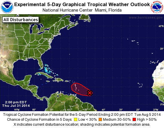
TROPICAL WEATHER OUTLOOK
NWS NATIONAL HURRICANE CENTER MIAMI FL
200 PM EDT THU JUL 31 2014

For the North Atlantic...Caribbean Sea and the Gulf of Mexico:

1. A Hurricane Hunter aircraft has recently begun investigating the
low pressure system located about 550 miles east of the southern
Windward Islands.  Preliminary reports from the aircraft indicate
that this system is producing winds to near gale force.  However,
satellite images indicate that the associated showers and
thunderstorms have diminished significantly since this morning.
Therefore the low currently does not meet the criteria to designate
it as a tropical cyclone.  Showers and thunderstorms could
redevelop later today or tonight, which could result in tropical
cyclone formation.  Interests in the Lesser Antilles should continue
to monitor the progress of this disturbance as it moves
west-northwestward at 15 to 20 mph, and watches or warnings may be
required for some of these islands later today or tonight.
* Formation chance through 48 hours...high...70 percent.
* Formation chance through 5 days...high...70 percent.

Forecaster Pasch
List of Atlantic Outlooks (May 2023 - present)
List of East Pacific Outlooks (May 2023 - present)
List of Central Pacific Outlooks (May 2023 - present)
List of Atlantic Outlooks (July 2014 - April 2023)
List of East Pacific Outlooks (July 2014 - April 2023)
List of Central Pacific Outlooks (June 2019 - April 2023)
List of Atlantic Outlooks (June 2009 - June 2014)
List of East Pacific Outlooks (June 2009 - June 2014)