


NHC Graphical Outlook Archive
|
« Earliest Available ‹ Earlier Later › Latest Available » |
| Eastern Pacific | Atlantic |
|
|
(mouse over weather symbols for details; click on weather symbols or disturbance numbers to switch views) |
Tropical Weather Outlook Text
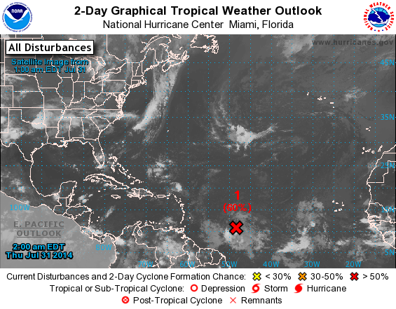
TROPICAL WEATHER OUTLOOK
NWS NATIONAL HURRICANE CENTER MIAMI FL
200 AM EDT THU JUL 31 2014

For the North Atlantic...Caribbean Sea and the Gulf of Mexico:

1. Satellite data indicate that shower activity has increased a little
in association with a well-defined low pressure system located about
850 miles east of the southern Windward Islands.  In addition, winds
to near tropical storm force are occurring over a small area just
north of the center.  While environmental conditions are only
marginally conducive for development, any additional increase in
organization could lead to the formation of a tropical depression
or tropical storm during the next day or so.  Interests in the
Lesser Antilles should monitor the progress of this system as it
moves west-northwestward near 15 mph.
* Formation chance through 48 hours...high...60 percent.
* Formation chance through 5 days...high...60 percent.

Forecaster Cangialosi
List of Atlantic Outlooks (May 2023 - present)
List of East Pacific Outlooks (May 2023 - present)
List of Central Pacific Outlooks (May 2023 - present)
List of Atlantic Outlooks (July 2014 - April 2023)
List of East Pacific Outlooks (July 2014 - April 2023)
List of Central Pacific Outlooks (June 2019 - April 2023)
List of Atlantic Outlooks (June 2009 - June 2014)
List of East Pacific Outlooks (June 2009 - June 2014)