


NHC Graphical Outlook Archive
|
« Earliest Available ‹ Earlier Later › Latest Available » |
| Eastern Pacific | Atlantic |
|
|
(mouse over weather symbols for details; click on weather symbols or disturbance numbers to switch views) |
Tropical Weather Outlook Text
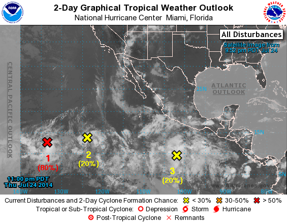
TROPICAL WEATHER OUTLOOK
NWS NATIONAL HURRICANE CENTER MIAMI FL
1100 PM PDT THU JUL 24 2014

For the eastern North Pacific...east of 140 degrees west longitude:

1. Satellite images indicate that shower activity has formed closer to
the circulation center of a low pressure area located about 1500
miles east-southeast of the Big Island of Hawaii.  The low is
already producing winds near tropical storm force north of the
center, and any additional increase in organization would lead to
the formation of a tropical depression.  The low is forecast to
move westward or west-northwestward at about 10 mph, and upper-level
winds are expected to become less conducive for development during
the weekend.
* Formation chance through 48 hours...high...80 percent.
* Formation chance through 5 days...high...80 percent.

2. An area of low pressure located about 1100 miles southwest of the
southern tip of the Baja California peninsula is producing
disorganized shower activity.  Some development is possible while
the system moves westward or west-northwestward at about 10 mph,
but upper-level winds are forecast to become unfavorable by early
next week.
* Formation chance through 48 hours...low...20 percent.
* Formation chance through 5 days...medium...40 percent.

3. A large area of disorganized showers and thunderstorms, associated
with a tropical wave, continues well south of the coast of southern
Mexico.  Upper-level winds are expected to become somewhat more
favorable for development of this system over the next few days
while it moves west-northwestward at 10 to 15 mph.
* Formation chance through 48 hours...low...20 percent.
* Formation chance through 5 days...medium...50 percent.

4. Another area of low pressure could form well south of southeastern
Mexico by early next week.  Some gradual development of this system
is possible after that time.
* Formation chance through 48 hours...low...near 0 percent.
* Formation chance through 5 days...low...20 percent.

Forecaster Berg
List of Atlantic Outlooks (May 2023 - present)
List of East Pacific Outlooks (May 2023 - present)
List of Central Pacific Outlooks (May 2023 - present)
List of Atlantic Outlooks (July 2014 - April 2023)
List of East Pacific Outlooks (July 2014 - April 2023)
List of Central Pacific Outlooks (June 2019 - April 2023)
List of Atlantic Outlooks (June 2009 - June 2014)
List of East Pacific Outlooks (June 2009 - June 2014)