


NHC Graphical Outlook Archive
|
« Earliest Available ‹ Earlier Later › Latest Available » |
| Eastern Pacific | Atlantic |
|
|
(mouse over shaded areas for details; click on shaded areas or disturbance numbers to switch views) |
Tropical Weather Outlook Text
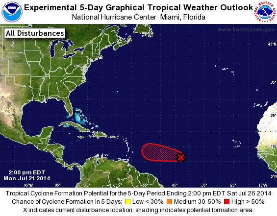
TROPICAL WEATHER OUTLOOK
NWS NATIONAL HURRICANE CENTER MIAMI FL
200 PM EDT MON JUL 21 2014

For the North Atlantic...Caribbean Sea and the Gulf of Mexico:

1. Shower activity associated with a small area of low pressure located
about 1250 miles east of the Lesser Antilles has continued to
increase and show signs of organization during the past few hours.
Satellite data indicate that the circulation has become better
defined and the system is producing a small area of winds near
tropical storm force. Only a small increase in organization of the
shower activity would result in the formation of a tropical
depression as the system moves westward to west-northwestward at 15
to 20 mph during the next day or two.  After that time, however,
environmental conditions are expected to become less conducive for
development or strengthening. Interests in the Lesser Antilles
should monitor the progress of this system.
* Formation chance through 48 hours...high...70 percent.
* Formation chance through 5 days...high...70 percent.

Forecaster Brennan
List of Atlantic Outlooks (May 2023 - present)
List of East Pacific Outlooks (May 2023 - present)
List of Central Pacific Outlooks (May 2023 - present)
List of Atlantic Outlooks (July 2014 - April 2023)
List of East Pacific Outlooks (July 2014 - April 2023)
List of Central Pacific Outlooks (June 2019 - April 2023)
List of Atlantic Outlooks (June 2009 - June 2014)
List of East Pacific Outlooks (June 2009 - June 2014)