ZCZC MIATWOEP ALL
TTAA00 KNHC DDHHMM
Tropical Weather Outlook
NWS National Hurricane Center Miami FL
500 AM PDT Wed Sep 14 2022
For the eastern North Pacific...east of 140 degrees west longitude:
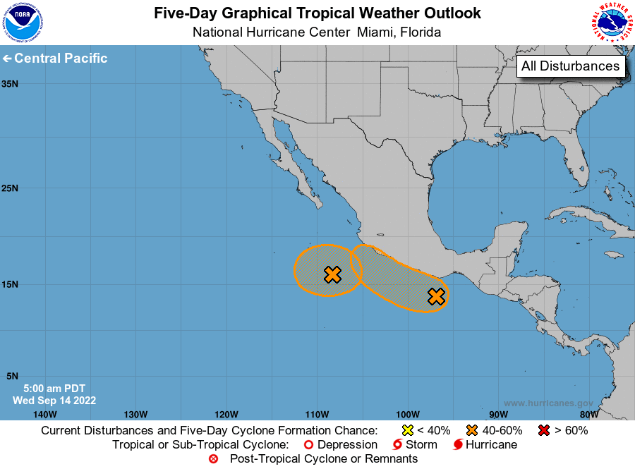
1. Southwest of Southwestern Mexico:
Showers and thunderstorms have become a little better organized
near a small area of low pressure located a few hundred miles
southwest of Manzanillo, Mexico. The chances for this low to
merge with another area of disturbed weather to its east-southeast
appear to be decreasing, and it could become a tropical depression
during the couple of days while meandering southwest of the
southwestern coast of Mexico.
* Formation chance through 48 hours...medium...40 percent.
* Formation chance through 5 days...medium...40 percent.
2. Near the Coast of Southern Mexico:
A large area of disorganized showers and thunderstorms a couple of
hundred miles off the coast of southern Mexico is associated with a
trough of low pressure. Environmental conditions would be
conducive for development if the system remains offshore, and a
tropical depression could form while moving little off the southern
coast of Mexico during the next couple of days, and then moving
west-northwestward near the coast of southern and southwestern
Mexico over the weekend.
* Formation chance through 48 hours...low...30 percent.
* Formation chance through 5 days...medium...60 percent.
Forecaster Berg