ZCZC MIATWOEP ALL
TTAA00 KNHC DDHHMM
Tropical Weather Outlook
NWS National Hurricane Center Miami FL
1100 PM PDT Fri Sep 13 2019
For the eastern North Pacific...east of 140 degrees west longitude:
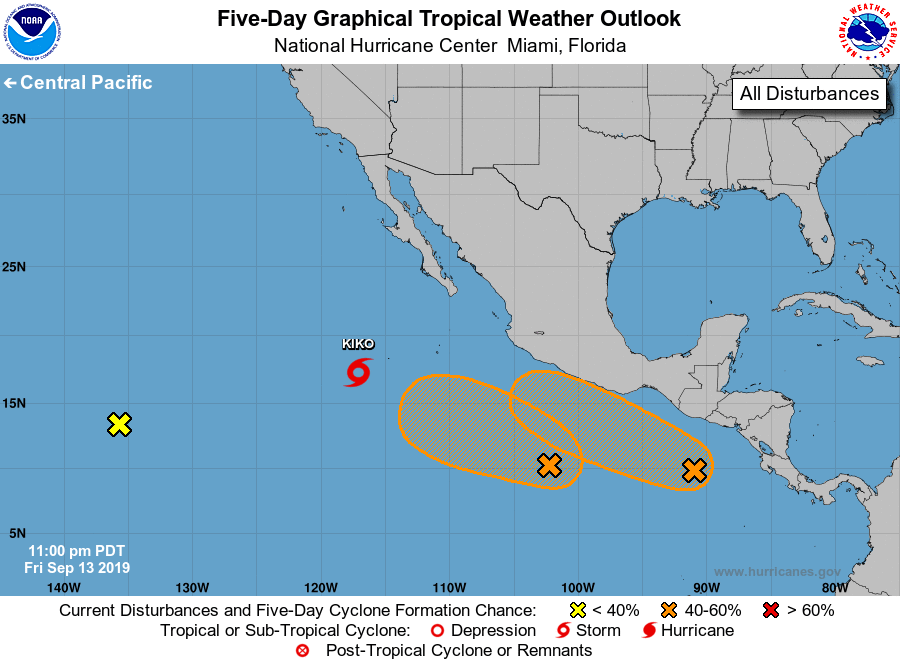
The National Hurricane Center is issuing advisories on Tropical
Storm Kiko, located several hundred miles southwest of the southern
tip of the Baja California peninsula.
1. Disorganized showers located about 1800 miles west-southwest of the
southern tip of the Baja California peninsula are associated with
an elongated trough of low pressure. Development of this system is
not expected as it begins to drift eastward into the larger
circulation of Tropical Storm Kiko during the next several days.
* Formation chance through 48 hours...low...near 0 percent.
* Formation chance through 5 days...low...near 0 percent.
2. Recent satellite-derived wind data indicate that a weak area of low
pressure has developed along an elongated trough about 500 miles
south-southwest of Acapulco, Mexico. This disturbance is producing
a large area of disorganized cloudiness, showers, and a few
thunderstorms. Some gradual development of this system is possible,
and a tropical depression could form by the middle of next week
while it moves slowly westward or west-northwestward well offshore
the southwestern coast of Mexico.
* Formation chance through 48 hours...low...10 percent.
* Formation chance through 5 days...medium...50 percent.
3. Satellite-derived wind data also indicate that a broad area of low
pressure is developing a few hundred miles south of the coast of
Guatemala. This system is producing a more concentrated but also
disorganized area of showers and thunderstorms. Environmental
conditions are forecast to be conducive for development, and a
tropical depression could form by the middle of next week while the
system moves west-northwestward, near or parallel to the coast of
Mexico.
* Formation chance through 48 hours...low...10 percent.
* Formation chance through 5 days...medium...50 percent.
Forecaster Berg