ZCZC MIATWOEP ALL
TTAA00 KNHC DDHHMM
Tropical Weather Outlook
NWS National Hurricane Center Miami FL
1100 AM PDT Sat Aug 10 2019
For the eastern North Pacific...east of 140 degrees west longitude:
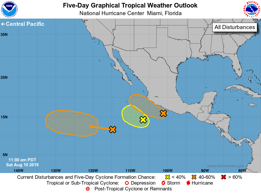
1. A trough of low pressure located about 100 miles southwest of
Acapulco, Mexico is producing a large area of showers and
thunderstorms. Some gradual development is possible during the next
couple of days and a tropical depression could form while the system
moves west-northwestward just off the southwestern coast of Mexico.
After that time, conditions are forecast to become unfavorable for
tropical cyclone formation. Regardless of development, the
disturbance will likely bring locally heavy rainfall along portions
of the southwestern coast of Mexico during the next couple of days.
* Formation chance through 48 hours...medium...40 percent.
* Formation chance through 5 days...medium...40 percent.
2. A broad area of low pressure located a few hundred miles
south-southwest of Manzanillo, Mexico is producing disorganized
showers and thunderstorms. Any development of this system during the
next day or so should be slow to occur due to its close proximity to
the disturbance near the coast of Mexico.
* Formation chance through 48 hours...low...20 percent.
* Formation chance through 5 days...low...20 percent.
3. An area of disturbed weather is located a little less than 1000
miles south-southwest of the Baja California peninsula.
Environmental conditions are expected to become more conducive for
tropical cyclone formation by the middle next week as this
disturbance moves westward or west- northwestward at 10 to 15 mph.
* Formation chance through 48 hours...low...near 0 percent.
* Formation chance through 5 days...medium...50 percent.
Forecaster Latto/Brown