ZCZC MIATWOEP ALL
TTAA00 KNHC DDHHMM
Tropical Weather Outlook
NWS National Hurricane Center Miami FL
1100 AM PDT Fri Aug 3 2018
For the eastern North Pacific...east of 140 degrees west longitude:
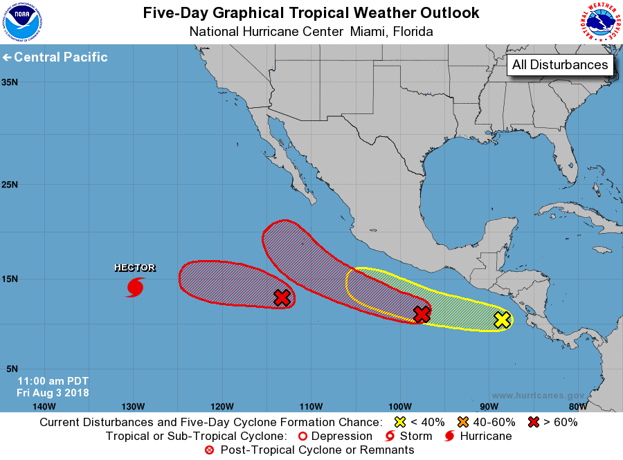
The National Hurricane Center is issuing advisories on Hurricane
Hector, located well southwest of Baja California Sur.
1. Satellite images indicate that a low pressure area has formed about
700 miles southwest of Manzanillo, Mexico, and is already showing
some signs of organization. Environmental conditions appear
conducive for further development, and a tropical depression is
likely to form over the weekend or early next week. The low is
forecast to move slowly westward over the next few days.
* Formation chance through 48 hours...medium...50 percent.
* Formation chance through 5 days...high...70 percent.
2. A large area of disturbed weather centered several hundred miles
southwest of the Gulf of Tehuantepec remains poorly organized.
However, environmental conditions are expected to be conducive for
development during the next several days, and a tropical depression
or tropical storm is expected to form by early next week while it
moves west-northwestward off the coast of Mexico.
* Formation chance through 48 hours...medium...40 percent.
* Formation chance through 5 days...high...90 percent.
3. A tropical wave just west of Central America is producing
disorganized cloudiness and showers. While development of this
system is possible over the next several days, strong upper-level
winds from a system to the northwest could prevent significant
organization. The wave is expected to move westward or
west-northwestward during the next few days.
* Formation chance through 48 hours...low...20 percent.
* Formation chance through 5 days...low...30 percent.
Forecaster Blake