ZCZC MIATWOEP ALL
TTAA00 KNHC DDHHMM
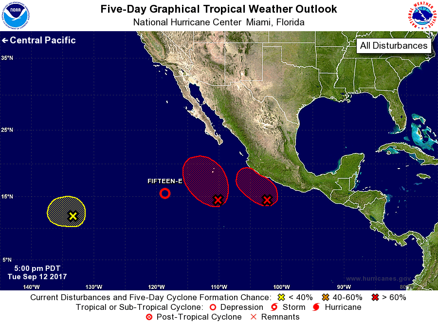
Tropical Weather Outlook
NWS National Hurricane Center Miami FL
500 PM PDT Tue Sep 12 2017
For the eastern North Pacific...east of 140 degrees west longitude:
The National Hurricane Center is issuing advisories on Tropical
Depression Fifteen-E, located several hundred miles southwest
of Cabo San Lucas, Mexico.
1. An elongated area of low pressure located a couple of hundred miles
south of the southern coast of Mexico is producing numerous showers
and thunderstorms. Environmental conditions are expected to
be conducive for development of this system, and a tropical
depression will likely form during the next day or so before it
moves over southwestern Mexico. Regardless of development, locally
heavy rains are expected to spread inland over southwestern
Mexico later this week. These rains could cause life-threatening
flash floods and mudslides.
* Formation chance through 48 hours...high...70 percent.
* Formation chance through 5 days...high...70 percent.
2. A broad area of low pressure located several hundred miles south of
the southern tip of the Baja California peninsula is producing
disorganized showers and thunderstorms. Environmental conditions
are expected to be conducive for development of this system, and a
tropical depression is likely to form by the end of the week while
it moves slowly northward.
* Formation chance through 48 hours...medium...50 percent.
* Formation chance through 5 days...high...80 percent.
3. Another area of low pressure is located more than 1500 miles
west-southwest of the Baja California peninsula. Development, if
any, of this system is expected to be slow to occur while it
meanders during the next several days.
* Formation chance through 48 hours...low...10 percent.
* Formation chance through 5 days...low...20 percent.
Forecaster Cangialosi