ZCZC MIATWOEP ALL
TTAA00 KNHC DDHHMM
TROPICAL WEATHER OUTLOOK
NWS NATIONAL HURRICANE CENTER MIAMI FL
500 AM PDT SUN SEP 4 2016
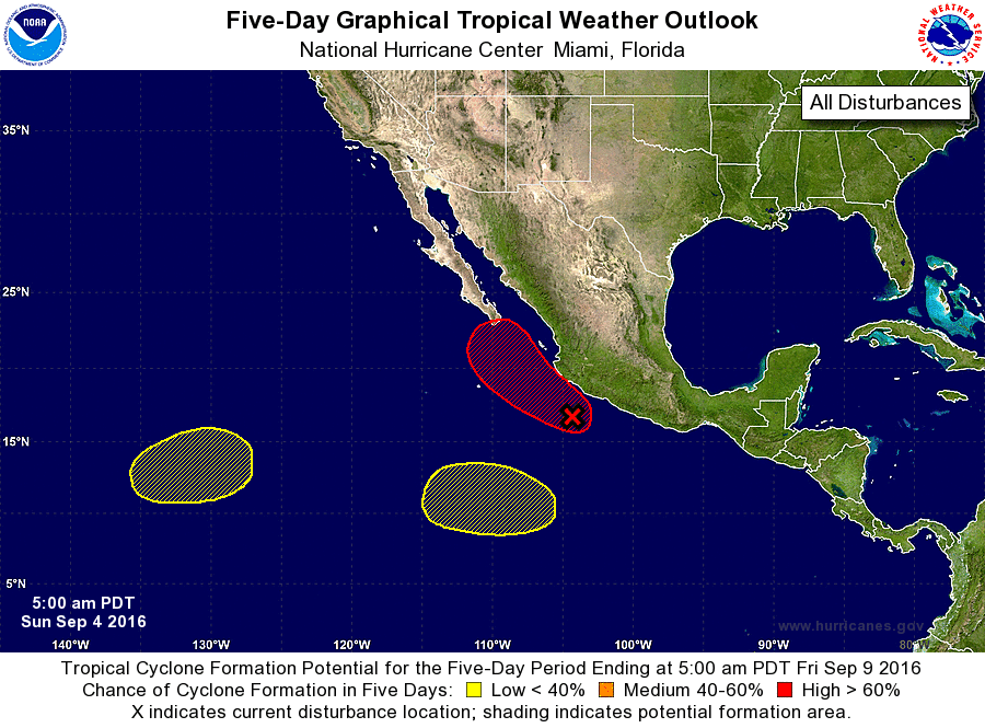
For the eastern North Pacific...east of 140 degrees west longitude:
1. A large area of showers and thunderstorms continue in association
with an elongated area of low pressure located just off the coast
of southwestern Mexico. Upper-level winds are forecast to become
more conducive for development, and a tropical depression is
expected to form later today or Monday while the disturbance moves
slowly northwestward, parallel to the southwestern coast of Mexico.
Regardless of whether or not development occurs, the system is
already bringing very heavy rains and gusty winds to southwestern
Mexico, and these conditions are likely to continue for the next
couple of days. Total rainfall amounts of 5 to 10 inches with
isolated totals up to 15 inches are possible across the southern
Mexico states of Oaxaca, Guerrero, Michoacan, Colima, Jalisco, and
Nayarit. These rains could produce life-threatening flash floods
and mud slides, especially in areas of mountainous terrain.
Interests in these areas as well as the Baja California peninsula
should monitor the progress of this disturbance.
* Formation chance through 48 hours...high...80 percent
* Formation chance through 5 days...high...90 percent
2. An area of low pressure could form in a couple of days about
thousand miles southwest of the southern tip of the Baja California
peninsula. Development, if any, of this system should be slow to
occur while the low meanders.
* Formation chance through 48 hours...low...near 0 percent
* Formation chance through 5 days...low...20 percent
3. Another area of low pressure is expected to form later this week
several hundred miles south or southwest of Manzanillo, Mexico. Some
gradual development of this system is possible after that time while
it moves generally westward.
* Formation chance through 48 hours...low...near 0 percent
* Formation chance through 5 days...low...20 percent
Forecaster Cangialosi