ZCZC MIATWOEP ALL
TTAA00 KNHC DDHHMM
TROPICAL WEATHER OUTLOOK
NWS NATIONAL HURRICANE CENTER MIAMI FL
500 PM PDT SAT SEP 3 2016
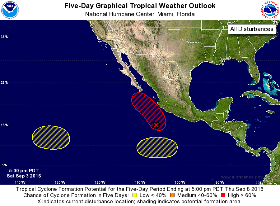
For the eastern North Pacific...east of 140 degrees west longitude:
1. Showers and thunderstorms associated with an elongated area of low
pressure continue to extend for several hundred miles near and
offshore the southern coast of Mexico. Satellite images indicate
that a more well-defined center of circulation may be developing
about 300 miles south-southwest of Manzanillo, Mexico, and the
thunderstorm activity in that area is showing some signs of
organization. Upper-level winds are becoming more conducive for
development, and a tropical depression is expected to form on
Sunday or Monday while the disturbance moves slowly northward and
then northwestward parallel to the southwestern coast of Mexico.
Regardless of development, the system is expected to bring gusty
winds and very heavy rains to southwestern Mexico. Total rainfall
amounts of 5 to 10 inches with isolated totals up to 15 inches are
expected through the weekend into early next week over the southern
Mexico states of Oaxaca, Guerrero, Michoacan, Colima, Jalisco, and
Nayarit. These rains could produce life-threatening flash floods
and mudslides, especially in areas of mountainous terrain.
Interests in these areas and Baja California Sur should monitor the
progress of this disturbance.
* Formation chance through 48 hours...high...80 percent
* Formation chance through 5 days...high...90 percent
2. An area of low pressure could form in a few days about 1500 miles
southwest of the southern tip of the Baja California peninsula.
Any development of this system should be slow to occur while the
system moves little.
* Formation chance through 48 hours...low...near 0 percent
* Formation chance through 5 days...low...20 percent
3. Another area of low pressure is likely to form by the middle of
next week well south of Mexico. Some gradual development of this
system is possible late next week while it moves generally westward.
* Formation chance through 48 hours...low...near 0 percent
* Formation chance through 5 days...low...20 percent
Forecaster Berg