


NHC Graphical Outlook Archive
|
« Earliest Available ‹ Earlier Later › Latest Available » |
GIS Shapefiles |
| Eastern North Pacific | Atlantic |
|
Tropical Weather Outlook Text
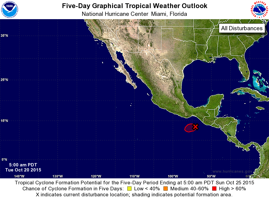
ZCZC MIATWOEP ALL
TTAA00 KNHC DDHHMM

TROPICAL WEATHER OUTLOOK
NWS NATIONAL HURRICANE CENTER MIAMI FL
500 AM PDT TUE OCT 20 2015

For the eastern North Pacific...east of 140 degrees west longitude:

1. Satellite data indicate that a tropical depression is likely forming
about 250 miles southeast of Puerto Escondido, Mexico, and if
additional data confirm this, advisories would be initiated later
today.  This system is expected to move generally westward and then
west-northwestward for the next few days, and interests along the
south-central and southwestern coasts of Mexico should continue to
closely monitor its progress. Locally heavy rains and gusty winds
associated with this system could affect portions of the
southeastern coast of Mexico during the next couple of days.
* Formation chance through 48 hours...high...near 100 percent
* Formation chance through 5 days...high...near 100 percent

Forecaster Kimberlain
List of Atlantic Outlooks (May 2023 - present)
List of East Pacific Outlooks (May 2023 - present)
List of Central Pacific Outlooks (May 2023 - present)
List of Atlantic Outlooks (July 2014 - April 2023)
List of East Pacific Outlooks (July 2014 - April 2023)
List of Central Pacific Outlooks (June 2019 - April 2023)
List of Atlantic Outlooks (June 2009 - June 2014)
List of East Pacific Outlooks (June 2009 - June 2014)