


NHC Graphical Outlook Archive
|
« Earliest Available ‹ Earlier Later › Latest Available » |
GIS Shapefiles |
| Eastern North Pacific | Atlantic |
|
Tropical Weather Outlook Text
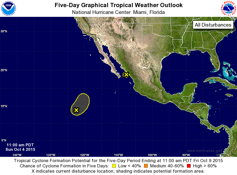
ZCZC MIATWOEP ALL
TTAA00 KNHC DDHHMM

TROPICAL WEATHER OUTLOOK
NWS NATIONAL HURRICANE CENTER MIAMI FL
1100 AM PDT SUN OCT 4 2015

For the eastern North Pacific...east of 140 degrees west longitude:

1. A broad and elongated area of low pressure located about 1000 miles
southwest of the southern tip of the Baja California peninsula
continues to produce an area of showers and thunderstorms.  While
some gradual development is possible during the next couple of days,
environmental conditions are expected to become less favorable
after that time while this system moves slowly northeastward or
northward.
* Formation chance through 48 hours...low...30 percent
* Formation chance through 5 days...low...30 percent

2. The remnants of Marty, located over the southern Gulf of California,
are producing a large area of showers and thunderstorms over
western Mexico.  This system is expected to moves inland later
today and development is not expected. Heavy rainfall is likely
to continue over portions of western Mexico during the next day or
so.
* Formation chance through 48 hours...low...near 0 percent
* Formation chance through 5 days...low...near 0 percent

Forecaster Cangialosi
List of Atlantic Outlooks (May 2023 - present)
List of East Pacific Outlooks (May 2023 - present)
List of Central Pacific Outlooks (May 2023 - present)
List of Atlantic Outlooks (July 2014 - April 2023)
List of East Pacific Outlooks (July 2014 - April 2023)
List of Central Pacific Outlooks (June 2019 - April 2023)
List of Atlantic Outlooks (June 2009 - June 2014)
List of East Pacific Outlooks (June 2009 - June 2014)