


NHC Graphical Outlook Archive
|
« Earliest Available ‹ Earlier Later › Latest Available » |
GIS Shapefiles |
| Eastern North Pacific | Atlantic |
|
Tropical Weather Outlook Text
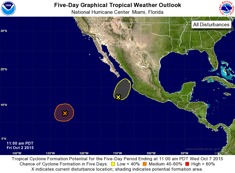
ZCZC MIATWOEP ALL
TTAA00 KNHC DDHHMM

TROPICAL WEATHER OUTLOOK
NWS NATIONAL HURRICANE CENTER MIAMI FL
1100 AM PDT FRI OCT 2 2015

For the eastern North Pacific...east of 140 degrees west longitude:

1. Showers and thunderstorms associated with a broad area of low
pressure located about 1200 miles southwest of the southern tip of
the Baja California peninsula have become less organized since
yesterday.  Environmental conditions are still forecast to be
somewhat conducive, so gradual development is possible during the
next few days while the systems moves little.
* Formation chance through 48 hours...low...30 percent
* Formation chance through 5 days...medium...50 percent

2. The remnants of Marty are centered about 350 miles west-southwest of
Manzanillo, Mexico.  Although the associated thunderstorm activity
has increased since yesterday, no significant development is
expected due to strong upper-level winds. Regardless of development,
areas of heavy rain are expected over portions of southwestern
Mexico later this weekend due to the system approaching the region.
* Formation chance through 48 hours...low...10 percent
* Formation chance through 5 days...low...10 percent

Forecaster Blake
List of Atlantic Outlooks (May 2023 - present)
List of East Pacific Outlooks (May 2023 - present)
List of Central Pacific Outlooks (May 2023 - present)
List of Atlantic Outlooks (July 2014 - April 2023)
List of East Pacific Outlooks (July 2014 - April 2023)
List of Central Pacific Outlooks (June 2019 - April 2023)
List of Atlantic Outlooks (June 2009 - June 2014)
List of East Pacific Outlooks (June 2009 - June 2014)