


NHC Graphical Outlook Archive
|
« Earliest Available ‹ Earlier Later › Latest Available » |
GIS Shapefiles |
| Eastern North Pacific | Atlantic |
|
Tropical Weather Outlook Text
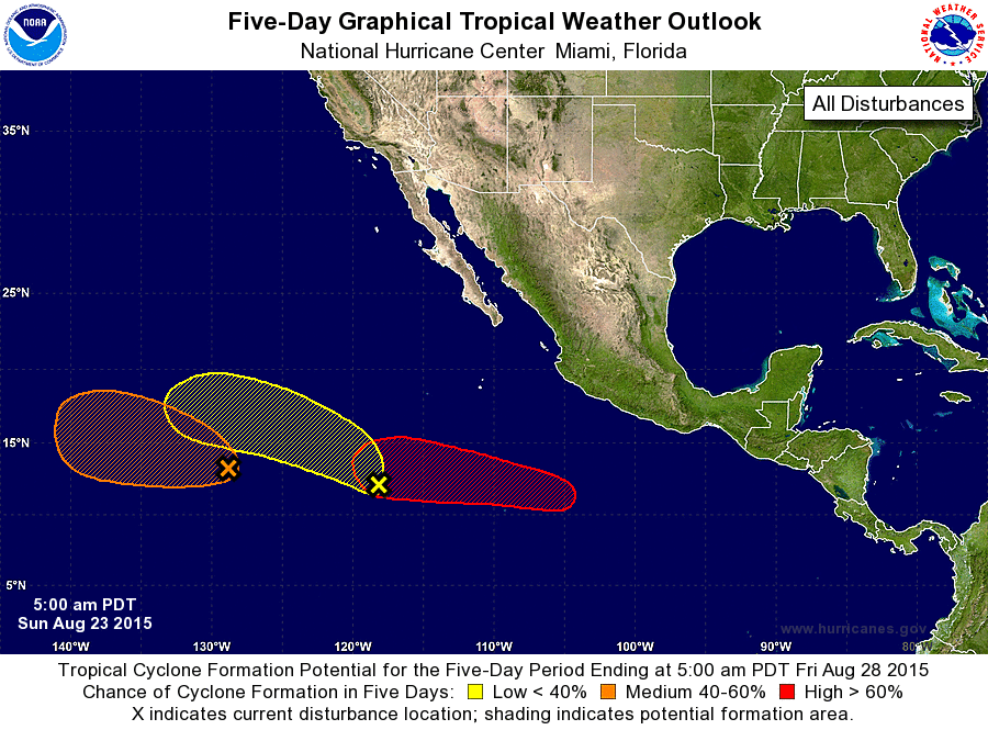
ZCZC MIATWOEP ALL
TTAA00 KNHC DDHHMM

TROPICAL WEATHER OUTLOOK
NWS NATIONAL HURRICANE CENTER MIAMI FL
500 AM PDT SUN AUG 23 2015

For the eastern North Pacific...east of 140 degrees west longitude:

1. Shower activity associated with a broad, slow-moving area of low
pressure located about 1400 miles west-southwest of the southern tip
of the Baja California peninsula remains limited and disorganized.
Environmental conditions are conducive for slow development as it
merges with a disturbance approaching it from the east, and a
tropical depression is likely to form later this week while the
system begins to moves westward to west-northwestward at 10 mph.
* Formation chance through 48 hours...low...20 percent
* Formation chance through 5 days...medium...60 percent

2. A large area of disorganized cloudiness and thunderstorms extends
northeastward from a broad area of low pressure located about 1000
miles southwest of the southern tip of the Baja California
peninsula. While some development of this system is possible during
the next few days, it most likely will merge with the disturbance to
its west as it moves northwestward and then west-northwestward at
about 10 at 15 mph.
* Formation chance through 48 hours...low...10 percent
* Formation chance through 5 days...low...20 percent

3. A low pressure area is expected to form well southwest of the coast
of southwestern Mexico in a few days.  Environmental conditions are
expected to be conducive for gradual development, and a tropical
depression is likely to form late this week while this system moves
westward and then west-northwestward at 10 to 15 mph.
* Formation chance through 48 hours...low...near 0 percent
* Formation chance through 5 days...high...70 percent

Forecaster Kimberlain
List of Atlantic Outlooks (May 2023 - present)
List of East Pacific Outlooks (May 2023 - present)
List of Central Pacific Outlooks (May 2023 - present)
List of Atlantic Outlooks (July 2014 - April 2023)
List of East Pacific Outlooks (July 2014 - April 2023)
List of Central Pacific Outlooks (June 2019 - April 2023)
List of Atlantic Outlooks (June 2009 - June 2014)
List of East Pacific Outlooks (June 2009 - June 2014)