


NHC Graphical Outlook Archive
|
« Earliest Available ‹ Earlier Later › Latest Available » |
GIS Shapefiles |
| Eastern North Pacific | Atlantic |
|
Tropical Weather Outlook Text
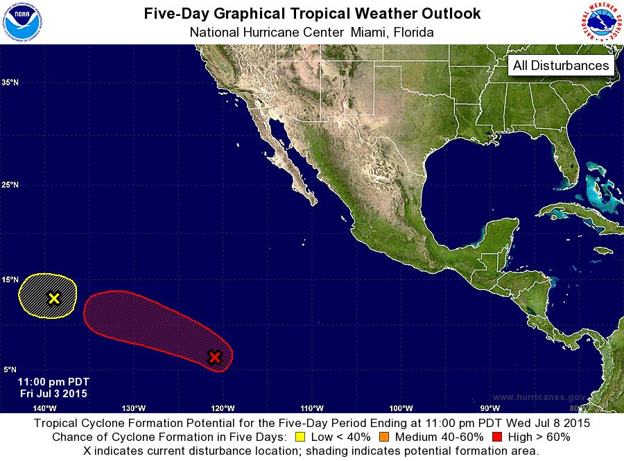
ZCZC MIATWOEP ALL
TTAA00 KNHC DDHHMM

TROPICAL WEATHER OUTLOOK
NWS NATIONAL HURRICANE CENTER MIAMI FL
1100 PM PDT FRI JUL 3 2015

For the eastern North Pacific...east of 140 degrees west longitude:

1. A small low pressure area located about 1200 miles east-southeast
of the Hawaiian Islands is producing limited shower activity.
Environmental conditions are gradually becoming less conducive
for development, and upper-level winds are expected to become
unfavorable by Sunday or Monday. The low is forecast to move
slowly west-northwestward for the next several days.
* Formation chance through 48 hours...low...30 percent
* Formation chance through 5 days...low...30 percent

2. A broad area of low pressure is producing extensive cloudiness and
scattered showers more than 1300 miles southwest of Cabo San Lucas
Mexico.  Environmental conditions are expected to gradually become
conducive for development, and a tropical depression is likely to
form by early next week while the system moves west-northwestward
at about 15 mph.
* Formation chance through 48 hours...medium...50 percent
* Formation chance through 5 days...high...90 percent

Forecaster Stewart
List of Atlantic Outlooks (May 2023 - present)
List of East Pacific Outlooks (May 2023 - present)
List of Central Pacific Outlooks (May 2023 - present)
List of Atlantic Outlooks (July 2014 - April 2023)
List of East Pacific Outlooks (July 2014 - April 2023)
List of Central Pacific Outlooks (June 2019 - April 2023)
List of Atlantic Outlooks (June 2009 - June 2014)
List of East Pacific Outlooks (June 2009 - June 2014)