


NHC Graphical Outlook Archive
|
« Earliest Available ‹ Earlier Later › Latest Available » |
GIS Shapefiles |
| Eastern North Pacific | Atlantic |
|
Tropical Weather Outlook Text
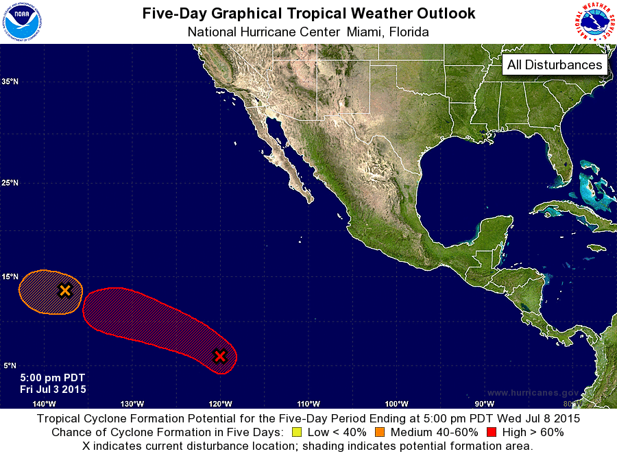
ZCZC MIATWOEP ALL
TTAA00 KNHC DDHHMM

TROPICAL WEATHER OUTLOOK
NWS NATIONAL HURRICANE CENTER MIAMI FL
500 PM PDT FRI JUL 3 2015

For the eastern North Pacific...east of 140 degrees west longitude:

1. A small low pressure area located about 1300 miles east-southeast
of the Hawaiian Islands is producing limited shower activity.
Environmental conditions are expected to be only marginally
conducive for development over the next couple of days before
upper-level winds become unfavorable by Monday. The low is forecast
to move slowly west-northwestward for the next several days.
* Formation chance through 48 hours...medium...40 percent
* Formation chance through 5 days...medium...40 percent

2. A tropical wave accompanied by a broad area of low pressure is
producing a large area of cloudiness and scattered showers more than
1300 miles south-southwest of Cabo San Lucas Mexico. Environmental
conditions are expected to be conducive for development, and a
tropical depression is likely to form by early next week while the
system moves to the west-northwest at 10 to 15 mph.
* Formation chance through 48 hours...medium...50 percent
* Formation chance through 5 days...high...90 percent

Forecaster Stewart
List of Atlantic Outlooks (May 2023 - present)
List of East Pacific Outlooks (May 2023 - present)
List of Central Pacific Outlooks (May 2023 - present)
List of Atlantic Outlooks (July 2014 - April 2023)
List of East Pacific Outlooks (July 2014 - April 2023)
List of Central Pacific Outlooks (June 2019 - April 2023)
List of Atlantic Outlooks (June 2009 - June 2014)
List of East Pacific Outlooks (June 2009 - June 2014)