


NHC Graphical Outlook Archive
|
« Earliest Available ‹ Earlier Later › Latest Available » |
| Eastern Pacific | Atlantic |
|
|
(mouse over shaded areas for details; click on shaded areas or disturbance numbers to switch views) |
Tropical Weather Outlook Text
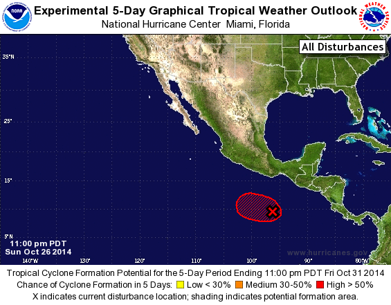
TROPICAL WEATHER OUTLOOK
NWS NATIONAL HURRICANE CENTER MIAMI FL
1100 PM PDT SUN OCT 26 2014

For the eastern North Pacific...east of 140 degrees west longitude

1. Showers and thunderstorms associated with an area of low pressure,
located several hundred miles south of the Gulf of Tehuantepec, have
changed little in organization during the last several hours.
However, satellite data indicate that the circulation of the low is
gradually becoming better defined.  Environmental conditions are
expected to be conducive for development this week while the low
drifts toward the west or west-northwest.
* Formation chance through 48 hours...medium...30 percent.
* Formation chance through 5 days...high...80 percent.

Forecaster Kimberlain
List of Atlantic Outlooks (May 2023 - present)
List of East Pacific Outlooks (May 2023 - present)
List of Central Pacific Outlooks (May 2023 - present)
List of Atlantic Outlooks (July 2014 - April 2023)
List of East Pacific Outlooks (July 2014 - April 2023)
List of Central Pacific Outlooks (June 2019 - April 2023)
List of Atlantic Outlooks (June 2009 - June 2014)
List of East Pacific Outlooks (June 2009 - June 2014)