


NHC Graphical Outlook Archive
|
« Earliest Available ‹ Earlier Later › Latest Available » |
| Eastern Pacific | Atlantic |
|
|
(mouse over shaded areas for details; click on shaded areas or disturbance numbers to switch views) |
Tropical Weather Outlook Text
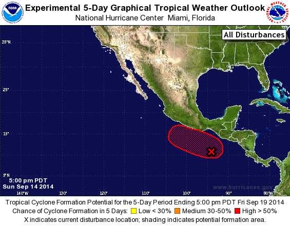
TROPICAL WEATHER OUTLOOK
NWS NATIONAL HURRICANE CENTER MIAMI FL
500 PM PDT SUN SEP 14 2014

For the eastern North Pacific...east of 140 degrees west longitude:

The National Hurricane Center is issuing advisories on Hurricane
Odile, located to the southeast of the southern tip of the Baja
California peninsula, and on Tropical Depression Sixteen-E, located
several hundred miles south-southwest of the southern tip of the
Baja California peninsula.

1. A broad area of low pressure located several hundred miles south of
the Gulf of Tehuantepec continues to produce disorganized showers
and thunderstorms.  Environmental conditions are expected to be
conducive for gradual development of this system during the next
several days while it moves slowly toward the west-northwest or
northwest.
* Formation chance through 48 hours...medium...40 percent.
* Formation chance through 5 days...high...70 percent.

Forecaster Pasch
List of Atlantic Outlooks (May 2023 - present)
List of East Pacific Outlooks (May 2023 - present)
List of Central Pacific Outlooks (May 2023 - present)
List of Atlantic Outlooks (July 2014 - April 2023)
List of East Pacific Outlooks (July 2014 - April 2023)
List of Central Pacific Outlooks (June 2019 - April 2023)
List of Atlantic Outlooks (June 2009 - June 2014)
List of East Pacific Outlooks (June 2009 - June 2014)