


NHC Graphical Outlook Archive
|
« Earliest Available ‹ Earlier Later › Latest Available » |
| Eastern Pacific | Atlantic |
|
|
(mouse over shaded areas for details; click on shaded areas or disturbance numbers to switch views) |
Tropical Weather Outlook Text
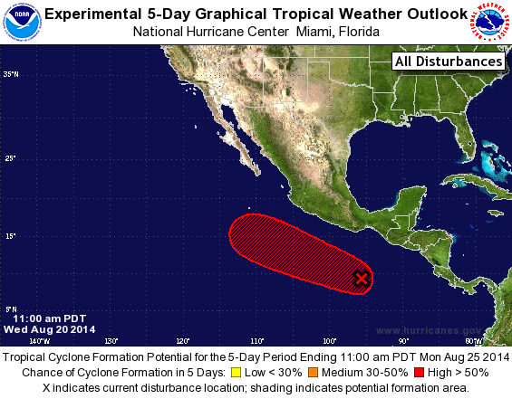
TROPICAL WEATHER OUTLOOK
NWS NATIONAL HURRICANE CENTER MIAMI FL
1100 AM PDT WED AUG 20 2014

For the eastern North Pacific...east of 140 degrees west longitude:

The National Hurricane Center is issuing advisories on Tropical
Storm Karina, located more than a thousand miles east of the Big
Island of Hawaii, and on Tropical Storm Lowell, located near 800
miles west-southwest of the southern tip of the Baja California
peninsula.

1. Cloudiness and showers associated with a broad area of low pressure
centered several hundred miles south of the Gulf of Tehuantepec
have increased this morning. Although there are no signs of
organization yet, conditions are forecast to be conducive for this
system to develop into a tropical depression by the end of the week
while it moves west-northwestward at about 10 mph.
* Formation chance through 48 hours...medium...50 percent.
* Formation chance through 5 days...high...80 percent.

Forecaster Avila
List of Atlantic Outlooks (May 2023 - present)
List of East Pacific Outlooks (May 2023 - present)
List of Central Pacific Outlooks (May 2023 - present)
List of Atlantic Outlooks (July 2014 - April 2023)
List of East Pacific Outlooks (July 2014 - April 2023)
List of Central Pacific Outlooks (June 2019 - April 2023)
List of Atlantic Outlooks (June 2009 - June 2014)
List of East Pacific Outlooks (June 2009 - June 2014)