


NHC Graphical Outlook Archive
|
« Earliest Available ‹ Earlier Later › Latest Available » |
| Eastern Pacific | Atlantic |
|
|
(mouse over shaded areas for details; click on shaded areas or disturbance numbers to switch views) |
Tropical Weather Outlook Text
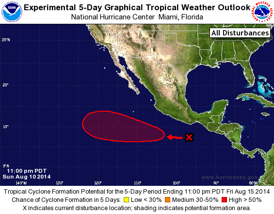
TROPICAL WEATHER OUTLOOK
NWS NATIONAL HURRICANE CENTER MIAMI FL
1100 PM PDT SUN AUG 10 2014

For the eastern North Pacific...east of 140 degrees west longitude:

1. A large area of cloudiness and showers centered a few hundred miles
south-southeast of Acapulco, Mexico, is associated with a tropical
wave.  Strong upper-level winds are expected to limit significant
development of the wave during the next couple of days.  After that
time, however, environmental conditions are expected to become more
conducive, and a tropical depression is likely to form later this
week while the system moves generally west-northwestward at 10 to 15
mph.
* Formation chance through 48 hours...low...10 percent.
* Formation chance through 5 days...high...70 percent.

Forecaster Blake
List of Atlantic Outlooks (May 2023 - present)
List of East Pacific Outlooks (May 2023 - present)
List of Central Pacific Outlooks (May 2023 - present)
List of Atlantic Outlooks (July 2014 - April 2023)
List of East Pacific Outlooks (July 2014 - April 2023)
List of Central Pacific Outlooks (June 2019 - April 2023)
List of Atlantic Outlooks (June 2009 - June 2014)
List of East Pacific Outlooks (June 2009 - June 2014)