


NHC Graphical Outlook Archive
|
« Earliest Available ‹ Earlier Later › Latest Available » |
| Eastern Pacific | Atlantic |
|
|
(mouse over shaded areas for details; click on shaded areas or disturbance numbers to switch views) |
Tropical Weather Outlook Text
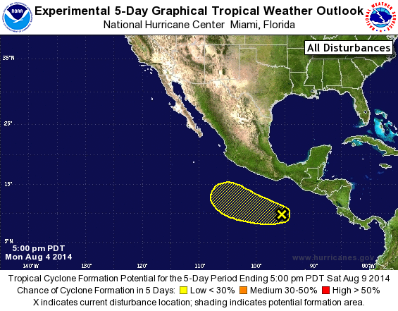
TROPICAL WEATHER OUTLOOK
NWS NATIONAL HURRICANE CENTER MIAMI FL
500 PM PDT MON AUG 4 2014

For the eastern North Pacific...east of 140 degrees west longitude:

The National Hurricane Center is issuing advisories on Hurricane
Iselle, located more than a thousand miles east of the Hawaiian
Islands, and on Tropical Storm Julio, located more than a thousand
miles southwest of the southern tip of the Baja California
peninsula.

1. A weak area of low pressure located several hundred miles
south-southwest of the Gulf of Tehuantepec is producing
disorganized showers and thunderstorms. Upper-level winds are
expected to remain strong over this system during the next several
days, and development, if any, should be slow to occur while the low
moves westward at about 10 mph.
* Formation chance through 48 hours...low...10 percent.
* Formation chance through 5 days...low...10 percent.

Public Advisories on Julio are issued under WMO header WTPZ35 KNHC
and under AWIPS header MIATCPEP5.  Forecast/Advisories are issued
under WMO header WTPZ25 KNHC and under AWIPS header MIATCMEP5.

Forecaster Brown
List of Atlantic Outlooks (May 2023 - present)
List of East Pacific Outlooks (May 2023 - present)
List of Central Pacific Outlooks (May 2023 - present)
List of Atlantic Outlooks (July 2014 - April 2023)
List of East Pacific Outlooks (July 2014 - April 2023)
List of Central Pacific Outlooks (June 2019 - April 2023)
List of Atlantic Outlooks (June 2009 - June 2014)
List of East Pacific Outlooks (June 2009 - June 2014)