


NHC Graphical Outlook Archive
|
« Earliest Available ‹ Earlier Later › Latest Available » |
| Eastern Pacific | Atlantic |
|
|
(mouse over shaded areas for details; click on shaded areas or disturbance numbers to switch views) |
Tropical Weather Outlook Text
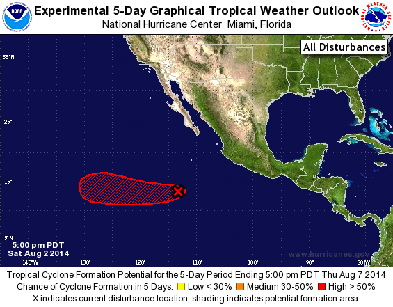
TROPICAL WEATHER OUTLOOK
NWS NATIONAL HURRICANE CENTER MIAMI FL
500 PM PDT SAT AUG 2 2014

For the eastern North Pacific...east of 140 degrees west longitude:

The National Hurricane Center is issuing advisories on Hurricane
Iselle, located more than a thousand miles west-southwest of the
southern tip of the Baja California peninsula.

1. A concentrated area of showers and thunderstorms is associated with
a low pressure system located about 725 miles southwest of
Manzanillo, Mexico.  Satellite data suggest that the circulation of
the low is not particularly well defined at the moment.  However,
environmental conditions are generally conducive for additional
development, and only a slight increase in organization would
result in the formation of a tropical depression during the next day
or two while the low moves westward at about 10 mph.
* Formation chance through 48 hours...high...90 percent.
* Formation chance through 5 days...high...near 100 percent.

Forecaster Kimberlain
List of Atlantic Outlooks (May 2023 - present)
List of East Pacific Outlooks (May 2023 - present)
List of Central Pacific Outlooks (May 2023 - present)
List of Atlantic Outlooks (July 2014 - April 2023)
List of East Pacific Outlooks (July 2014 - April 2023)
List of Central Pacific Outlooks (June 2019 - April 2023)
List of Atlantic Outlooks (June 2009 - June 2014)
List of East Pacific Outlooks (June 2009 - June 2014)