


NHC Graphical Outlook Archive
|
« Earliest Available ‹ Earlier Later › Latest Available » |
| Eastern Pacific | Atlantic |
|
|
(mouse over shaded areas for details; click on shaded areas or disturbance numbers to switch views) |
Tropical Weather Outlook Text
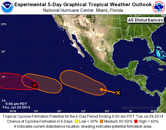
TROPICAL WEATHER OUTLOOK
NWS NATIONAL HURRICANE CENTER MIAMI FL
500 AM PDT THU JUL 24 2014

For the eastern North Pacific...east of 140 degrees west longitude:

A surface trough located about 1150 miles east-southeast of the
Big Island of Hawaii has moved into the central Pacific basin.
Please see the Tropical Weather Outlook from the Central Pacific
Hurricane Center for more details.

1. A low pressure system located about 1550 miles southwest of the
southern tip of the Baja California peninsula has changed little
overnight.  Environmental conditions appear conducive for
development, and this system is expected to become a tropical
depression during the next day or two while it moves westward or
west-northwestward at about 10 mph.
* Formation chance through 48 hours...high...80 percent.
* Formation chance through 5 days...high...80 percent.

2. A large area of disorganized showers and thunderstorms has formed
well south of the coast of southeastern Mexico.  Upper-level winds
are expected to become more favorable for development of this system
over the next few days while its moves generally west-northwestward
at 10 to 15 mph.
* Formation chance through 48 hours...low...10 percent.
* Formation chance through 5 days...medium...50 percent.

3. Another area of low pressure could form during the next couple of
days roughly 1000 miles southwest of the southern tip of the Baja
California peninsula.  Some gradual development of this system
is possible by the weekend while it moves generally
west-northwestward at 10 to 15 mph.
* Formation chance through 48 hours...low...near 0 percent.
* Formation chance through 5 days...medium...30 percent.

The central Pacific Tropical Weather Outlook can be found under
AWIPS header HFOTWOCP and WMO header ACPN50 PHFO.

Forecaster Blake
List of Atlantic Outlooks (May 2023 - present)
List of East Pacific Outlooks (May 2023 - present)
List of Central Pacific Outlooks (May 2023 - present)
List of Atlantic Outlooks (July 2014 - April 2023)
List of East Pacific Outlooks (July 2014 - April 2023)
List of Central Pacific Outlooks (June 2019 - April 2023)
List of Atlantic Outlooks (June 2009 - June 2014)
List of East Pacific Outlooks (June 2009 - June 2014)