ZCZC MIATWOAT ALL
TTAA00 KNHC DDHHMM
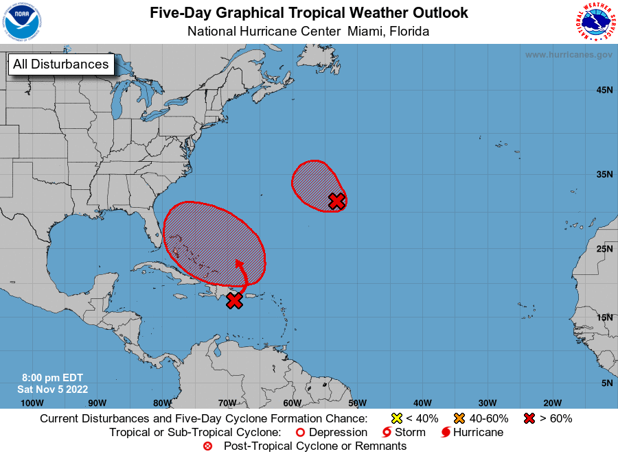
Tropical Weather Outlook
NWS National Hurricane Center Miami FL
800 PM EDT Sat Nov 5 2022
For the North Atlantic...Caribbean Sea and the Gulf of Mexico:
1. Central Subtropical Atlantic:
Showers and thunderstorms have become better organized in
association with an area of low pressure located several hundred
miles east of Bermuda. Additionally, the system appears to be
acquiring some tropical characteristics as it separates from a
nearby decaying frontal system. If these trends continue, a
short-lived tropical depression or storm is likely to form tonight
or on Sunday while the system moves slowly west-northwestward to
northwestward over the central Atlantic. The system is forecast to
turn northward and northeastward and merge with a strong cold front
by the middle of next week, and further development is not expected
beyond that time. Additional information on this system, including
gale warnings, can be found in High Seas Forecasts issued by the
National Weather Service.
* Formation chance through 48 hours...high...70 percent.
* Formation chance through 5 days...high...70 percent.
2. Southwestern Atlantic:
A trough of low pressure located over the northeastern Caribbean Sea
is producing a large area of disorganized showers and thunderstorms.
The trough is forecast to move northward over the southwestern
Atlantic on Sunday, where a broad area of low pressure is expected
to form north of Hispaniola. Environmental conditions are forecast
to be conducive for gradual development, and a subtropical or
tropical depression is likely to form early next week while the
system moves generally westward to west-northwestward over the
southwestern Atlantic. Regardless of development, there is an
increasing risk of coastal flooding, gale-force winds, heavy
rainfall, rough surf, and beach erosion along much of the
southeastern United States coast, the Florida east coast, and
portions of the central and northwestern Bahamas during the early to
middle part of next week. The disturbance is also expected to bring
locally heavy rainfall to Puerto Rico and the Virgin Islands this
weekend. Interests in those areas should monitor the progress of
this system.
* Formation chance through 48 hours...medium...50 percent.
* Formation chance through 5 days...high...80 percent.
High Seas Forecasts issued by the National Weather Service
can be found under AWIPS header NFDHSFAT1, WMO header FZNT01
KWBC, and online at ocean.weather.gov/shtml/NFDHSFAT1.php
Forecaster Reinhart/Bucci