ZCZC MIATWOAT ALL
TTAA00 KNHC DDHHMM
Tropical Weather Outlook
NWS National Hurricane Center Miami FL
200 PM EDT Fri Nov 4 2022
For the North Atlantic...Caribbean Sea and the Gulf of Mexico:
Active Systems:
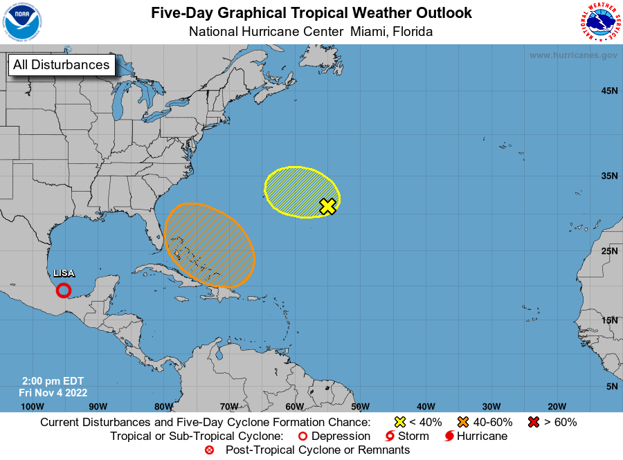
The National Hurricane Center is issuing advisories on Tropical
Depression Lisa, located over the Bay of Campeche.
1. East-Southeast of Bermuda:
A weak non-tropical area of low pressure located several hundred
miles east-southeast of Bermuda continues to produce an area of
showers and thunderstorms, mostly well to the east of its center.
Any tropical or subtropical development of this disturbance should
be slow to occur during the next day or so while it moves westward
or west-northwestward over the weekend. The system is forecast to
interact with a larger low pressure area developing to its southwest
and will encounter stronger upper level winds on Saturday, so
further development is not anticipated beyond that time.
* Formation chance through 48 hours...low...10 percent.
* Formation chance through 5 days...low...10 percent.
2. Southwestern Atlantic:
A large non-tropical low pressure system is expected to develop
across the northeastern Caribbean Sea and southwestern Atlantic by
the latter part of the weekend. The system is initially expected be
very broad and disorganized, but it could begin to acquire
subtropical or tropical characteristics during the early part next
week. Environmental conditions could support additional gradual
development and a subtropical or tropical depression could form
during the early to middle portion of next week while the system
moves generally northwestward or westward over the southwestern
Atlantic. Regardless of development, there is an increasing risk of
coastal flooding, gale-force winds, heavy rainfall, rough surf, and
beach erosion along much of the southeastern United States coast,
the Florida east coast, and portions of the central and
northwestern Bahamas during the early to middle part of next
week.
* Formation chance through 48 hours...low...near 0 percent.
* Formation chance through 5 days...medium...40 percent.
Forecaster Brown