Skip Navigation Links
NOAA NOAA United States Department of Commerce

NHC Graphical Outlook Archive


« Earliest Available         ‹ Earlier         Later ›         Latest Available »
GIS Shapefiles
Central Pacific Eastern Pacific Atlantic

View 2-Day Graphical Tropical Weather Outlook
Click for Eastern Pacific Click for Eastern Pacific

Tropical Weather Outlook Text

ZCZC MIATWOAT ALL
TTAA00 KNHC DDHHMM

Tropical Weather Outlook
NWS National Hurricane Center Miami FL
200 PM EDT Mon Aug 22 2022

For the North Atlantic...Caribbean Sea and the Gulf of Mexico:

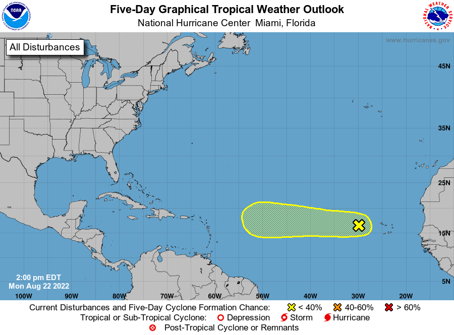
1. Eastern Tropical Atlantic: 
Showers and thunderstorms have become a little more concentrated 
today in association with a tropical wave located a few hundred 
miles west of the Cabo Verde Islands. Environmental conditions could 
support some slow development of this system while it moves westward 
to west-northwestward at around 10 to 15 mph across the tropical 
Atlantic during the next several days. 
* Formation chance through 48 hours...low...10 percent.
* Formation chance through 5 days...low...30 percent.

Forecaster Latto


List of Atlantic Outlooks (May 2023 - present)
List of East Pacific Outlooks (May 2023 - present)
List of Central Pacific Outlooks (May 2023 - present)
List of Atlantic Outlooks (July 2014 - April 2023)
List of East Pacific Outlooks (July 2014 - April 2023)
List of Central Pacific Outlooks (June 2019 - April 2023)
List of Atlantic Outlooks (June 2009 - June 2014)
List of East Pacific Outlooks (June 2009 - June 2014)