ZCZC MIATWOAT ALL
TTAA00 KNHC DDHHMM
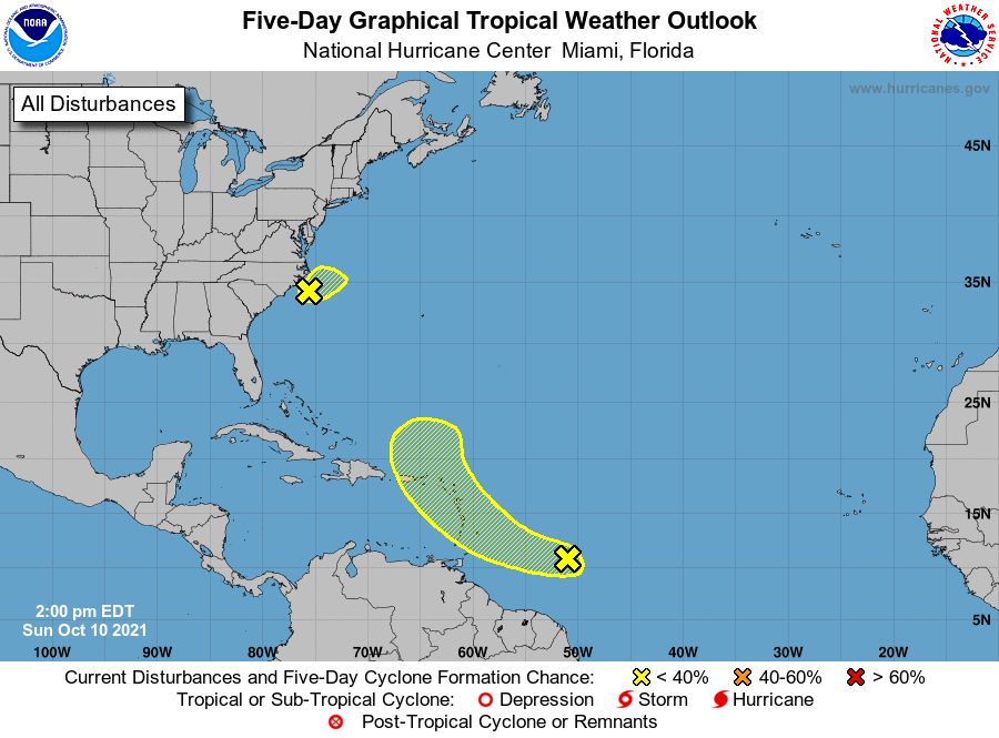
Tropical Weather Outlook
NWS National Hurricane Center Miami FL
200 PM EDT Sun Oct 10 2021
For the North Atlantic...Caribbean Sea and the Gulf of Mexico:
1. Shower and thunderstorm activity remains disorganized in association
with a large, non-tropical low pressure area located about 80 miles
south of Cape Hatteras, North Carolina. An Air Force Reserve
reconnaissance aircraft that investigated the low earlier today
found that the system was still producing a small area of
gale-force winds just offshore the North Carolina outer banks.
However, dry air and strong upper-level winds are expected to
decrease the chance for further development of this system. The low
is forecast to move slowly northeastward today, with the center
remaining just offshore the eastern North Carolina coast this
afternoon and tonight. Interests in that area should continue to
monitor the progress of this system and refer to local National
Weather Service office products for more information. Regardless of
development, intermittent periods of locally heavy rains and gusty
winds will affect southeastern and eastern portions of North
Carolina during the next day or so. Additional information on this
low pressure system, including gale warnings, can be found in High
Seas Forecasts issued by the National Weather Service.
* Formation chance through 48 hours...low...20 percent.
* Formation chance through 5 days...low...20 percent.
2. Recent satellite-derived surface wind data indicate that a vigorous
tropical wave located about 500 miles east-southeast of the Windward
Islands is producing a concentrated area of cloudiness and
thunderstorms near the wave axis. Environmental conditions are
forecast to be marginally conducive for some additional development
of this system while it moves west-northwestward at about 15 mph
over the next few days. The disturbance is expected to approach the
central and northern Lesser Antilles by late Monday and early
Tuesday, and interests in these areas should monitor the progress of
this system. Regardless of development, the system will produce
locally heavy rainfall and gusty winds across portions of the
central and northern Lesser Antilles on Tuesday, and across the
Virgin Islands and northern Lesser Antilles on Wednesday.
* Formation chance through 48 hours...low...20 percent.
* Formation chance through 5 days...low...30 percent.
High Seas Forecasts issued by the National Weather Service can be
found under AWIPS header NFDHSFAT1, WMO header FZNT01 KWBC, and
online at ocean.weather.gov/shtml/NFDHSFAT1.php
Forecaster Stewart