ZCZC MIATWOAT ALL
TTAA00 KNHC DDHHMM
Tropical Weather Outlook
NWS National Hurricane Center Miami FL
200 AM EDT Wed Sep 29 2021
For the North Atlantic...Caribbean Sea and the Gulf of Mexico:
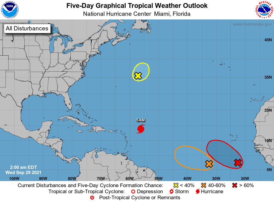
The National Hurricane Center is issuing advisories on Hurricane
Sam, located several hundred miles east of the northern Leeward
Islands.
1. Shower and thunderstorm activity associated with an area of
low pressure located several hundred miles south of the Cabo
Verde Islands continues to gradually become better organized.
Environmental conditions are conducive for additional development,
and a tropical depression or tropical storm is likely to form later
today or tonight while the disturbance moves west-northwestward at
10 to 15 mph over the eastern tropical Atlantic. Additional
information on this system, including gale warnings, can be found
in High Seas Forecasts issued by Meteo France.
* Formation chance through 48 hours...high...90 percent.
* Formation chance through 5 days...high...90 percent.
2. Showers and thunderstorms remain disorganized in association with a
a broad and elongated area of low pressure located several hundred
miles southwest of the Cabo Verde Islands. Although environmental
conditions are generally conducive for development during the next
day or so, interaction of this system with the low pressure area
located to its east is likely to hinder development after that time.
The system is forecast to drift west-northwestward over the next
few days.
* Formation chance through 48 hours...medium...50 percent.
* Formation chance through 5 days...medium...50 percent.
3. An area of low pressure associated with the remnants of Peter is
located several hundred miles east-northeast of Bermuda. Recent
satellite wind data indicate that the circulation of the low has
become less defined, and shower activity remains limited. The system
is moving northeastward into a region of very strong upper-level
winds, and significant development of this system is no longer
anticipated. Additional information on this system can be found in
High Seas Forecasts issued by the National Weather Service.
* Formation chance through 48 hours...low...10 percent.
* Formation chance through 5 days...low...10 percent.
High Seas Forecasts issued by the National Weather Service can be
found under AWIPS header NFDHSFAT1, WMO header FZNT01 KWBC, and
online at ocean.weather.gov/shtml/NFDHSFAT1.php
High Seas Forecasts issued by Meteo France can be found under WMO
header FQNT50 LFPW and available on the web at
www.meteofrance.com/previsions-meteo-marine/bulletin/grandlarge/
metarea2
Forecaster Brown