ZCZC MIATWOAT ALL
TTAA00 KNHC DDHHMM
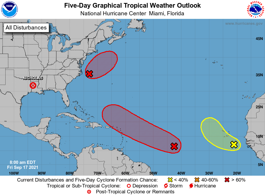
Tropical Weather Outlook
NWS National Hurricane Center Miami FL
800 AM EDT Fri Sep 17 2021
For the North Atlantic...Caribbean Sea and the Gulf of Mexico:
The Weather Prediction Center is issuing advisories on
Post-Tropical Cyclone Nicholas, located over Louisiana.
1. Showers and thunderstorms remain disorganized in association with a
tropical wave and broad area of low pressure located about midway
between the Lesser Antilles and the Cabo Verde Islands. However,
environmental conditions are expected to be conducive for
development during the next few days, and a tropical depression
is still likely to form over the weekend or early next week while
moving toward the west-northwest at 15 to 20 mph across the central
tropical Atlantic and then near or north of the Leeward Islands by
Monday and Tuesday. Interests in the Leeward Islands should
monitor the progress of this system during the next few days.
* Formation chance through 48 hours...medium...60 percent.
* Formation chance through 5 days...high...70 percent.
2. The circulation associated with an area of low pressure located
about 150 miles east of Cape Hatteras, North Carolina, remains
broad and elongated, and most of the associated shower and
thunderstorm activity is displaced well to the north and east of
the center. However, this system is still likely to become a
short-lived tropical depression or tropical storm before it makes a
transition to a non-tropical gale-force low by Saturday or Saturday
night while moving northeastward at about 15 mph away from the
United States mid-Atlantic and Northeast coasts. Regardless of
development, this system could bring high surf to portions of the
mid-Atlantic and Northeast U.S. coasts and Atlantic Canada through
this weekend. Additional information on this system, including gale
warnings, can be found in High Seas Forecasts issued by the NOAA
Ocean Prediction Center.
* Formation chance through 48 hours...high...70 percent.
* Formation chance through 5 days...high...70 percent.
3. Disorganized cloudiness and thunderstorms over the far eastern
tropical Atlantic are associated with a tropical wave located a
couple of hundred miles southeast of the Cabo Verde Islands.
Environmental conditions are forecast to be only marginally
conducive, and development, if any, of this system should be slow to
occur over the next few days while the system moves toward the
west-northwest or northwest at 5 to 10 mph over the far eastern
Atlantic.
* Formation chance through 48 hours...low...10 percent.
* Formation chance through 5 days...low...20 percent.
Public advisories issued by the Weather Prediction Center on
Post-Tropical Cyclone Nicholas can be found under AWIPS header
TCPAT4, WMO header WTNT34 KWNH, and on the web at
https://www.wpc.ncep.noaa.gov or hurricanes.gov
High Seas Forecasts for the system off the Outer Banks of North
Carolina issued by the NOAA Ocean Prediction Center can be found
under AWIPS header NFDHSFAT1, WMO header FZNT01 KWBC, and online at
ocean.weather.gov/shtml/NFDHSFAT1.php
Forecaster Berg