ZCZC MIATWOAT ALL
TTAA00 KNHC DDHHMM
Tropical Weather Outlook
NWS National Hurricane Center Miami FL
200 PM EDT Wed Sep 15 2021
For the North Atlantic...Caribbean Sea and the Gulf of Mexico:
The Weather Prediction Center is issuing advisories on Tropical
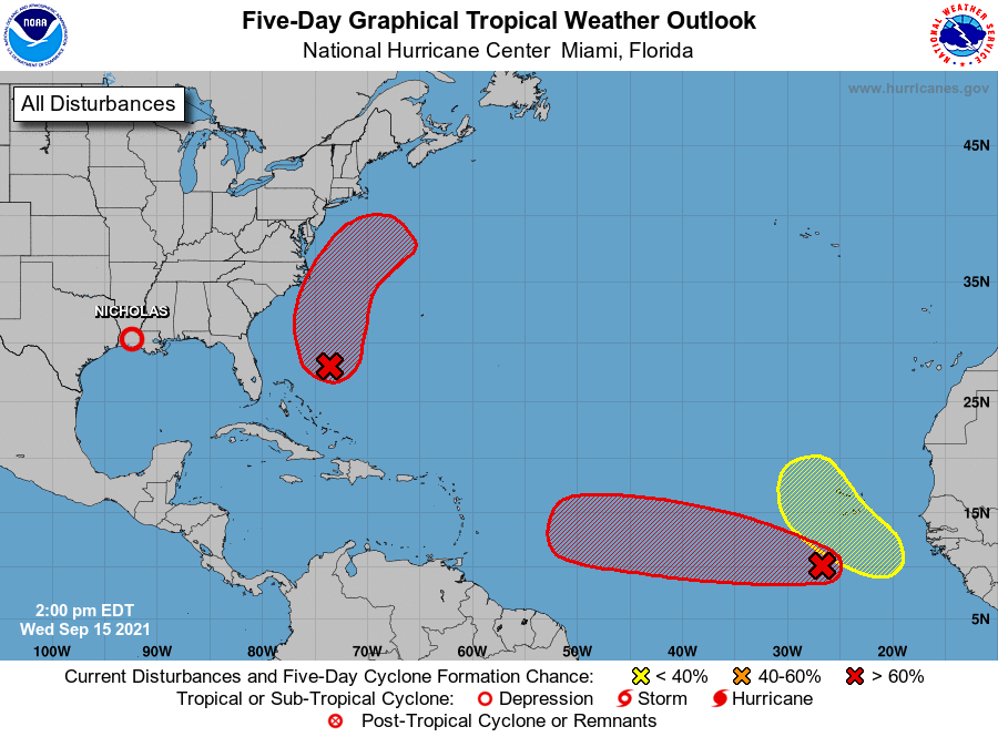
Depression Nicholas, located near the Texas/Louisiana border.
1. Showers and thunderstorms have changed little in organization in
association with an area of low pressure located a few hundred
miles southwest of the Cabo Verde Islands. Environmental
conditions are expected to remain conducive for development, and a
tropical depression is likely to form within the next couple of
days. This system is expected to move westward to
west-northwestward across the tropical Atlantic during the next
several days.
* Formation chance through 48 hours...high...80 percent.
* Formation chance through 5 days...high...90 percent.
2. Satellite images indicate that a low pressure system located a few
hundred miles northeast of the central Bahamas is gradually becoming
better defined. However, the associated showers and thunderstorms
are still disorganized. Environmental conditions are expected to
become more conducive for development, and a tropical depression is
likely to form during the next day or two while the system moves
north-northwestward to northward off the southeast U.S. coast.
Regardless of development, this system could bring high surf to
portions of the southeast and mid-Atlantic U.S. coasts later this
week. The Air Force Hurricane Hunters are currently enroute to
investigate the disturbance.
* Formation chance through 48 hours...high...70 percent.
* Formation chance through 5 days...high...70 percent.
3. A tropical wave is expected to emerge off the west coast of
Africa in a day or two. Thereafter, environmental conditions are
forecast to be conducive for development while the system moves
generally west-northwestward to northwestward over the
far eastern Atlantic.
* Formation chance through 48 hours...low...near 0 percent.
* Formation chance through 5 days...low...20 percent.
Public advisories issued by the Weather Prediction Center on
Tropical Depression Nicholas can be found under AWIPS header TCPAT4,
WMO header WTNT34 KWNH, and on the web at
http://www.wpc.ncep.noaa.gov.
Forecaster Cangialosi