ZCZC MIATWOAT ALL
TTAA00 KNHC DDHHMM
Tropical Weather Outlook
NWS National Hurricane Center Miami FL
200 AM EDT Wed Sep 15 2021
For the North Atlantic...Caribbean Sea and the Gulf of Mexico:
The National Hurricane Center has issued its last advisory on
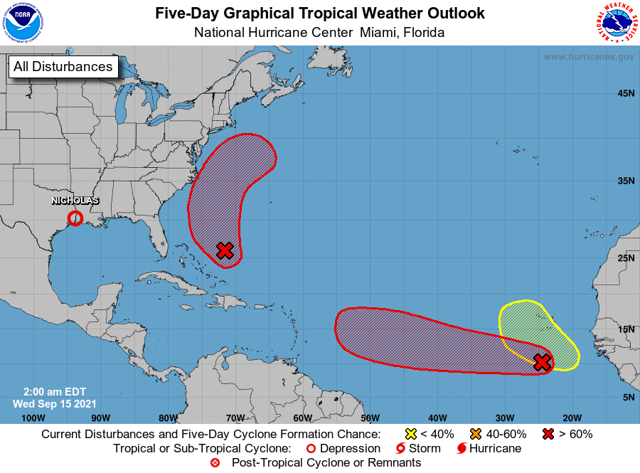
Tropical Depression Nicholas, located just west of the Texas and
Louisiana border. Future advisories on Nicholas will be issued by
the Weather Prediction Center.
1. Showers and thunderstorms associated with a low pressure area
located a few hundred miles south of the Cabo Verde Islands continue
to show signs of organization. Environmental conditions are
expected to remain conducive for development, and a tropical
depression is likely to form during the next couple of days while
the system moves generally westward at about 15 mph across the
eastern tropical Atlantic Ocean.
* Formation chance through 48 hours...high...80 percent.
* Formation chance through 5 days...high...90 percent.
2. A trough of low pressure located a few hundred miles northeast of
the central Bahamas is producing a large area of disorganized
showers and thunderstorms. Environmental conditions appear
marginally conducive for gradual development during the next few
days, and a tropical depression is likely to form while the system
moves north-northwestward to northward across the western Atlantic.
* Formation chance through 48 hours...medium...60 percent.
* Formation chance through 5 days...high...70 percent.
3. A tropical wave is expected to emerge off of the west coast of
Africa toward the end of the week. Thereafter, environmental
conditions are forecast to be conducive for development while the
system moves generally west-northwestward to northwestward over the
far eastern Atlantic.
* Formation chance through 48 hours...low...near 0 percent.
* Formation chance through 5 days...low...20 percent.
Public advisories issued by the Weather Prediction Center on
Tropical Depression Nicholas can be found under AWIPS header TCPAT4,
WMO header WTNT34 KWNH, and on the web at
http://www.wpc.ncep.noaa.gov.
Forecaster Papin