ZCZC MIATWOAT ALL
TTAA00 KNHC DDHHMM
Tropical Weather Outlook
NWS National Hurricane Center Miami FL
200 AM EDT Sun Sep 12 2021
For the North Atlantic...Caribbean Sea and the Gulf of Mexico:
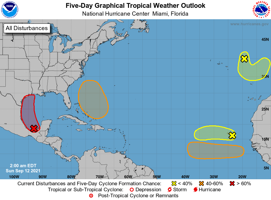
1. Showers and thunderstorms over the Bay of Campeche and southern
Gulf of Mexico have been increasing during the past several hours
near and east of a surface trough of low pressure. A tropical
depression is expected to form later today or tonight while the
system moves northwestward and then northward near the coast of
northeastern Mexico. Additional development is possible through
the middle of next week if the system remains over water, and
interests along the western and northwestern Gulf coast should
monitor the progress of this disturbance. An Air Force Hurricane
Hunter aircraft is scheduled to investigate the system this
morning, and potential tropical cyclone advisories could be
initiated later today.
Regardless of development, the disturbance will continue to produce
heavy rain across portions of southern Mexico today, including the
western Yucatan Peninsula, which may lead to flash flooding and
mudslides. By late today, heavy rain is expected to reach portions
of the Texas and Louisiana coasts with a heavy rain threat
continuing across those coasts through the middle of the week.
Localized significant rainfall amounts are possible, potentially
resulting in areas of flash, urban, and isolated river flooding.
* Formation chance through 48 hours...high...90 percent.
* Formation chance through 5 days...high...90 percent.
2. Disorganized showers and a few thunderstorms continue in
association with a tropical wave located near the Cabo Verde
Islands. Environmental conditions are becoming less conducive for
development, and the chances of tropical depression formation are
decreasing while the system moves westward over the far eastern
Atlantic. By the middle of the week, stronger upper-level winds
and marginally warm ocean temperatures are expected to limit
additional development. This disturbance could bring locally heavy
rain across the Cabo Verde Islands today.
* Formation chance through 48 hours...low...30 percent.
* Formation chance through 5 days...low...30 percent.
3. A non-tropical area of low pressure is located over the far
northeastern Atlantic several hundred miles northeast of the
Azores. This system is forecast to move south-southeastward towards
warmer waters, which could allow the low to gradually acquire some
tropical or subtropical characteristics by the middle of next week.
* Formation chance through 48 hours...low...20 percent.
* Formation chance through 5 days...low...20 percent.
4. Another tropical wave is forecast to move off the west coast of
Africa in a couple of days. Gradual development of this system is
possible thereafter, and a tropical depression could form by the
middle of the week while it moves westward across the eastern
tropical Atlantic Ocean.
* Formation chance through 48 hours...low...near 0 percent.
* Formation chance through 5 days...medium...60 percent.
5. An area of low pressure is expected to form north of the
southeastern Bahamas in a few days resulting from the northern end
of a tropical wave interacting with an upper-level trough. Gradual
development of this system is possible, and a tropical depression
could form by the middle of the week several hundred miles
southeast of the Carolinas while it moves northwestward across the
western Atlantic.
* Formation chance through 48 hours...low...near 0 percent.
* Formation chance through 5 days...medium...40 percent.
Forecaster Blake