ZCZC MIATWOAT ALL
TTAA00 KNHC DDHHMM
Tropical Weather Outlook
NWS National Hurricane Center Miami FL
200 PM EDT Sat Sep 11 2021
For the North Atlantic...Caribbean Sea and the Gulf of Mexico:
The National Hurricane Center has issued the last advisory on
Post-Tropical Cyclone Larry, located over the Labrador Sea.
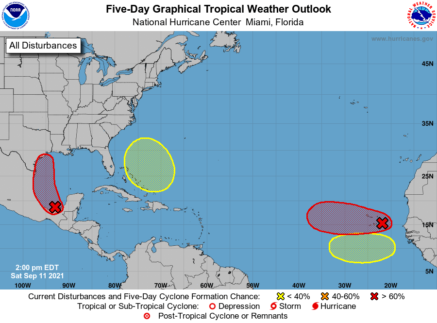
1. A tropical wave and an upper-level trough continue to produce a
large area of disorganized showers and thunderstorms over portions
of southeastern Mexico and the southern and central Gulf of Mexico.
Although upper-level winds are not conducive for development
currently, they are expected to become more favorable for the system
during the next day or so. A tropical depression is likely to form
on Sunday or Monday while the disturbance moves northwestward and
then northward near the coast of northeastern Mexico. Further
development will be possible through the middle of next week if it
remains over water, and interests along the western and northwestern
Gulf coast should monitor the progress of this system. An Air Force
Hurricane Hunter aircraft is scheduled to investigate the system
tomorrow.
Regardless of development, this disturbance is expected to produce
heavy rain across portions of Central America and the Yucatan
Peninsula through today which may lead to flash flooding and
mudslides. By late this weekend, heavy rain will likely reach
portions of the western Gulf coast, including coastal Texas and
Louisiana through the middle of next week. Localized significant
rainfall amounts will be possible, potentially resulting in areas of
flash and urban flooding.
* Formation chance through 48 hours...high...80 percent.
* Formation chance through 5 days...high...90 percent.
2. Showers and thunderstorms have not become any better organized in
association with a tropical wave located just southeast of the Cabo
Verde Islands. Environmental conditions appear generally conducive
for gradual development, and a tropical depression is likely to form
late this weekend or early next week while the system moves westward
over the far eastern Atlantic. Regardless of development, this
disturbance is likely to bring gusty winds and locally heavy rain
across the Cabo Verde Islands later today and tonight.
* Formation chance through 48 hours...medium...50 percent.
* Formation chance through 5 days...high...70 percent.
3. Another tropical wave is expected to move off the west coast of
Africa in a few days. Some development of this system will be
possible through the middle of next week while it moves westward
across the eastern tropical Atlantic Ocean.
* Formation chance through 48 hours...low...near 0 percent.
* Formation chance through 5 days...low...20 percent.
4. An area of low pressure is expected to form near the southeastern
Bahamas in a few days. Gradual development of this system is
possible thereafter as it moves northwestward across the western
Atlantic.
* Formation chance through 48 hours...low...near 0 percent.
* Formation chance through 5 days...low...20 percent.
Forecaster Cangialosi