ZCZC MIATWOAT ALL
TTAA00 KNHC DDHHMM
Special Tropical Weather Outlook
NWS National Hurricane Center Miami FL
320 PM EDT Wed Sep 8 2021
For the North Atlantic...Caribbean Sea and the Gulf of Mexico:
Special outlook issued to update discussion of the disturbance in
the Gulf of Mexico.
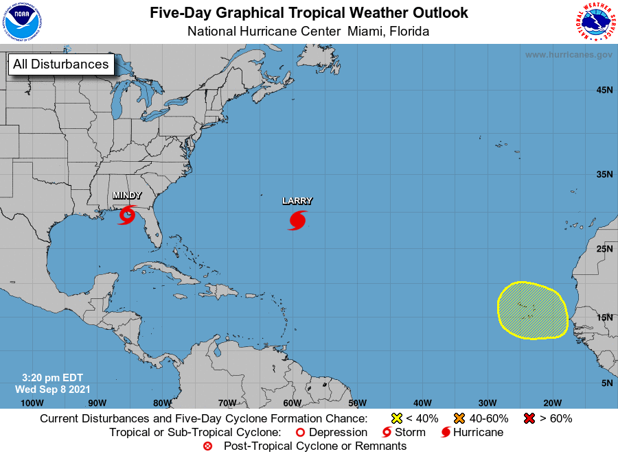
The National Hurricane Center is issuing advisories on Hurricane
Larry, located over the central Atlantic several hundred miles
east-southeast of Bermuda.
1. Updated: Satellite and radar data indicate that shower and
thunderstorm activity continues to gradually become better organized
in association with an area of low pressure located about 115 miles
southwest of Apalachicola, Florida. In addition, satellite-derived
wind data indicate that the circulation has become somewhat better
defined today. If these development trends continue, advisories will
likely be initiated on this system as a tropical depression or
tropical storm later this afternoon, and tropical storm warnings
could be required for portions of the coast of the Florida
Panhandle. After reaching the Florida Panhandle tonight, this system
is expected to move across the southeastern United States and emerge
over the western Atlantic by late Thursday, where environmental
conditions appear unfavorable for additional development.
Regardless of development, areas of heavy rainfall are likely across
portions of the Florida panhandle and southern Georgia through
Thursday, with localized flooding possible.
* Formation chance through 48 hours...high...80 percent.
* Formation chance through 5 days...high...80 percent.
2. A tropical wave is expected to emerge off of the western coast of
Africa in a few days. Some development of this system is possible
thereafter as it moves west-northwestward over the far eastern
Atlantic.
* Formation chance through 48 hours...low...near 0 percent.
* Formation chance through 5 days...low...20 percent.
Forecaster Brennan/Papin