ZCZC MIATWOAT ALL
TTAA00 KNHC DDHHMM
Tropical Weather Outlook
NWS National Hurricane Center Miami FL
200 AM EDT Fri Sep 3 2021
For the North Atlantic...Caribbean Sea and the Gulf of Mexico:
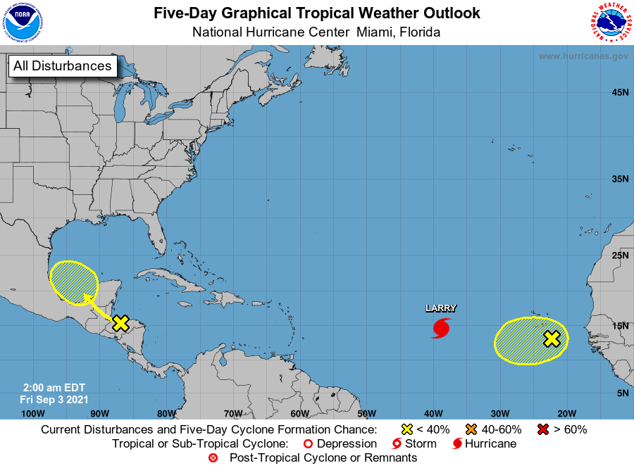
The National Hurricane Center is issuing advisories on Hurricane
Larry, located over the eastern tropical Atlantic several hundred
miles west of the southernmost Cabo Verde Islands.
1. A surface trough over the Gulf of Honduras and portions of Central
America is producing disorganized shower and thunderstorm activity.
This system is expected to move west-northwestward across Central
America and the Yucatan Peninsula, bringing heavy rains to that area
during the next couple of days. The disturbance could then move
over the southwestern Gulf of Mexico late this weekend, but
unfavorable upper-level winds are likely to limit significant
development while the system moves northwestward or northward over
the western Gulf of Mexico early next week.
* Formation chance through 48 hours...low...near 0 percent.
* Formation chance through 5 days...low...20 percent.
2. Showers and thunderstorms have decreased tonight in association with
an area of disturbed weather located about 100 miles south of the
southernmost Cabo Verde Islands. In addition, recent satellite
derived wind data indicate that the system does not have a closed
circulation. This disturbance is expected to move westward into an
environment less conducive for development during the next couple of
days, and the chances of formation appear to be decreasing. This
system could bring showers and gusty winds to portions of the
southernmost Cabo Verde Islands during the next several hours.
* Formation chance through 48 hours...low...20 percent.
* Formation chance through 5 days...low...20 percent.
Forecaster Cangialosi