Skip Navigation Links
NOAA NOAA United States Department of Commerce

NHC Graphical Outlook Archive


« Earliest Available         ‹ Earlier         Later ›         Latest Available »
GIS Shapefiles
Central Pacific Eastern Pacific Atlantic

View 2-Day Graphical Tropical Weather Outlook
Click for Eastern Pacific Click for Eastern Pacific

Tropical Weather Outlook Text

ZCZC MIATWOAT ALL
TTAA00 KNHC DDHHMM

Tropical Weather Outlook
NWS National Hurricane Center Miami FL
200 AM EDT Mon Jun 21 2021

For the North Atlantic...Caribbean Sea and the Gulf of Mexico:

The National Hurricane Center is issuing advisories on Tropical 
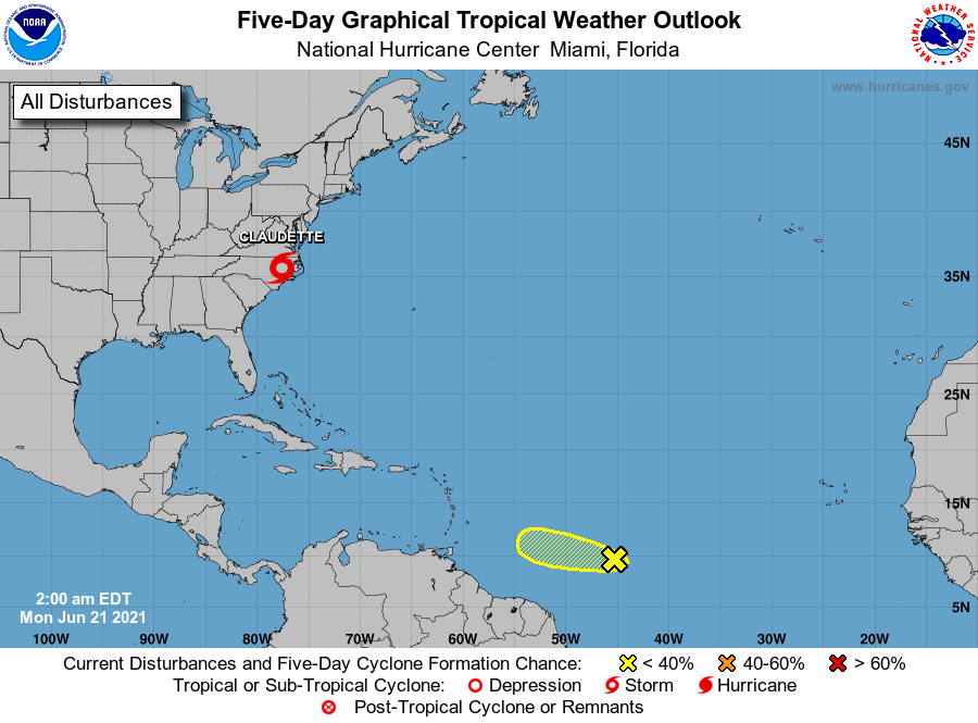
Depression Claudette, located inland over North Carolina.

1. A tropical wave located about 1000 miles east of the Windward 
Islands is producing a small area of thunderstorm activity.  This 
system has a slight chance of development during the next couple of 
days before upper-level winds become less conducive for further 
organization by Thursday.  The wave is expected to move westward at 
10 to 15 mph.
* Formation chance through 48 hours...low...10 percent.
* Formation chance through 5 days...low...10 percent.

Forecaster Blake


List of Atlantic Outlooks (May 2023 - present)
List of East Pacific Outlooks (May 2023 - present)
List of Central Pacific Outlooks (May 2023 - present)
List of Atlantic Outlooks (July 2014 - April 2023)
List of East Pacific Outlooks (July 2014 - April 2023)
List of Central Pacific Outlooks (June 2019 - April 2023)
List of Atlantic Outlooks (June 2009 - June 2014)
List of East Pacific Outlooks (June 2009 - June 2014)