ZCZC MIATWOAT ALL
TTAA00 KNHC DDHHMM
Tropical Weather Outlook
NWS National Hurricane Center Miami FL
800 AM EDT Sun Oct 4 2020
For the North Atlantic...Caribbean Sea and the Gulf of Mexico:
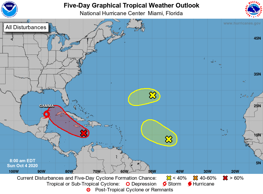
The National Hurricane Center is issuing advisories on Tropical
Storm Gamma, located just north of the Yucatan Peninsula over the
extreme southern Gulf of Mexico.
1. A tropical wave accompanied by a low pressure system is located over
the central Caribbean Sea a couple of hundred miles southeast of
Jamaica. The associated shower and thunderstorm activity is
beginning to show some signs of organization. Environmental
conditions are expected to be conducive for additional development,
and a tropical depression is likely to form within the next day or
two. The system should move west-northwestward at 10 to 15 mph
across the central and western Caribbean Sea today through Tuesday,
and then move into the southern or southeastern Gulf of Mexico on
Tuesday night and Wednesday. Locally heavy rainfall and gusty
winds will be possible across portions of Hispaniola, Jamaica, Cuba,
and the Cayman Islands during the next few days, and interests on
those islands should monitor the progress of this disturbance.
* Formation chance through 48 hours...high...70 percent.
* Formation chance through 5 days...high...80 percent.
2. Disorganized showers and thunderstorms continue in association with
a tropical wave located over the central tropical Atlantic. This
system has not become any better organized, and any development
during the next day or so should be slow to occur while it moves
west-northwestward or northwestward at 10 to 15 mph. Significant
development is not expected beyond that time due to the system
moving into a region of strong upper-level winds.
* Formation chance through 48 hours...low...10 percent.
* Formation chance through 5 days...low...10 percent.
3. An area of disorganized showers and thunderstorms over the central
Atlantic about 1000 miles east-southeast of Bermuda is associated
with a surface trough of low pressure. This system is expected to
move toward the west-southwest at around 10 mph, and some slow
development is possible during the next couple of days before it too
encounters strong upper-level winds.
* Formation chance through 48 hours...low...10 percent.
* Formation chance through 5 days...low...10 percent.
Forecaster Brown