ZCZC MIATWOAT ALL
TTAA00 KNHC DDHHMM
Tropical Weather Outlook
NWS National Hurricane Center Miami FL
800 AM EDT Fri Oct 2 2020
For the North Atlantic...Caribbean Sea and the Gulf of Mexico:
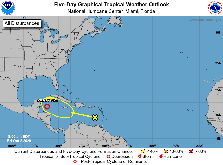
1. Satellite imagery indicates that shower activity associated with
the broad low pressure area over the northwestern Caribbean Sea
continues to become better organized. Environmental conditions are
expected to be conducive for a tropical depression or a tropical
storm to form later today or on Saturday if the system remains over
the waters of the northwestern Caribbean Sea or the southern Gulf
of Mexico. Interests in the Yucatan Peninsula and northern Central
America should monitor the progress of this system while it moves
generally northwestward, as tropical storm watches or warnings may
be required for portions of these areas later today or tonight.
Regardless of development, this system is expected to produce heavy
rains, with possible flash flooding, over portions of southeastern
Mexico, Central America, and western Cuba during the next several
days. An Air Force Reserve reconnaissance aircraft is scheduled to
investigate the system this afternoon, if necessary.
* Formation chance through 48 hours...high...90 percent.
* Formation chance through 5 days...high...90 percent.
2. A tropical wave over the eastern Caribbean Sea is producing
a large area of disorganized showers and thunderstorms,
accompanied by locally heavy rainfall and gusty winds. This wave
is forecast to move westward at 15 to 20 mph during the next
several days, and environmental conditions could become a little
more conducive for development when the system is over the central
or western Caribbean Sea early next week.
* Formation chance through 48 hours...low...near 0 percent.
* Formation chance through 5 days...low...30 percent.
Forecaster Pasch