ZCZC MIATWOAT ALL
TTAA00 KNHC DDHHMM
Tropical Weather Outlook
NWS National Hurricane Center Miami FL
800 PM EDT Fri Sep 18 2020
For the North Atlantic...Caribbean Sea and the Gulf of Mexico:
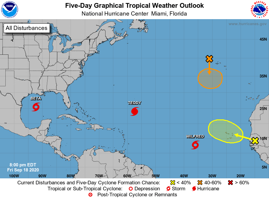
The National Hurricane Center is issuing advisories on Hurricane
Teddy, located over the central Atlantic, on recently upgraded
Tropical Storm Beta, located over the western Gulf of Mexico, on
Tropical Storm Wilfred, located over the eastern tropical Atlantic,
and on Subtropical Storm Alpha, located inland over northwestern
Portugal.
1. Post-Tropical Cyclone Paulette is located near the western Azores.
The cyclone is forecast to move southward for the next couple of
days and then stall over marginally warm waters a few hundred miles
south of the Azores by the end of the weekend. The cyclone could
redevelop tropical characteristics late this weekend or early next
week while it moves little. For more information about marine
hazards associated with this system, see High Seas Forecasts issued
by Meteo France.
* Formation chance through 48 hours...low...30 percent.
* Formation chance through 5 days...medium...40 percent.
2. Another tropical wave is forecast to move off the west coast of
Africa by early Saturday. Some slow development of the system will
be possible thereafter while it moves generally west-northwestward
over the far eastern Atlantic.
* Formation chance through 48 hours...low...near 0 percent.
* Formation chance through 5 days...low...20 percent.
Public Advisories on Tropical Storm Wilfred are issued under WMO
header WTNT33 KNHC and under AWIPS header MIATCPAT3.
Forecast/Advisories on Tropical Storm Wilfred are issued
under WMO header WTNT23 KNHC and under AWIPS header MIATCMAT3.
Public Advisories on Subtropical Storm Alpha are issued under WMO
header WTNT34 KNHC and under AWIPS header MIATCPAT4.
Forecast/Advisories on Tropical Storm Wilfred are issued
under WMO header WTNT24 KNHC and under AWIPS header MIATCMAT4.
High Seas Forecasts issued by Meteo France can be found under WMO
header FQNT50 LFPW and available on the web at
www.meteofrance.com/previsions-meteo-marine/bulletin/grandlarge/
metarea2
Forecaster Pasch