ZCZC MIATWOAT ALL
TTAA00 KNHC DDHHMM
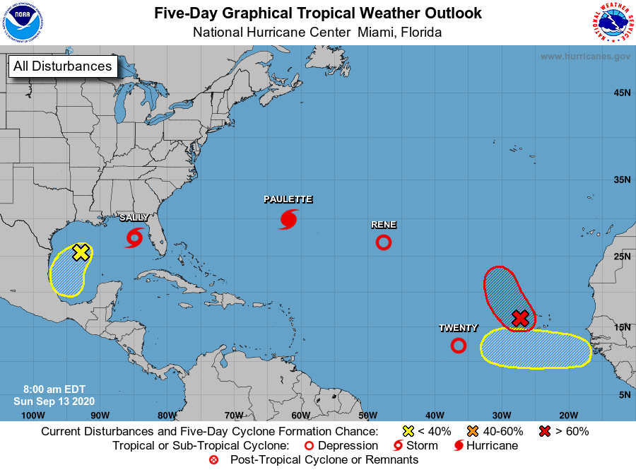
Tropical Weather Outlook
NWS National Hurricane Center Miami FL
800 AM EDT Sun Sep 13 2020
For the North Atlantic...Caribbean Sea and the Gulf of Mexico:
The National Hurricane Center is issuing advisories on Hurricane
Paulette, located over the western Atlantic, Tropical Depression
Rene, located over the central Atlantic, on Tropical Storm Sally,
centered over the eastern Gulf of Mexico, and on Tropical Depression
Twenty, located over the eastern tropical Atlantic.
1. A surface trough over the west-central Gulf of Mexico is producing
limited shower activity. Any development of this system is
expected to be slow to occur while it moves southwestward and then
southward at 5 to 10 mph over the western Gulf of Mexico during
the next few days.
* Formation chance through 48 hours...low...10 percent.
* Formation chance through 5 days...low...20 percent.
2. An area of low pressure is located a little over a hundred miles
west of the Cabo Verde Islands. Although the low's circulation
appears somewhat elongated, the associated shower and thunderstorm
activity is showing some signs of organization. Environmental
conditions are expected to be conducive for additional development
during the next day or so while the system moves toward the
north-northwest at 5 to 10 mph, and a tropical depression is likely
to form before it moves over colder waters and into an area of
strong upper-level winds by Tuesday.
* Formation chance through 48 hours...high...70 percent.
* Formation chance through 5 days...high...70 percent.
3. A tropical wave is forecast to move off the west coast of Africa
within the next couple of days. Some gradual development of the
system will be possible thereafter as the disturbance moves slowly
westward over the far eastern tropical Atlantic.
* Formation chance through 48 hours...low...near 0 percent.
* Formation chance through 5 days...low...20 percent.
Public Advisories on Tropical Depression Twenty are issued under
WMO header WTNT35 KNHC and under AWIPS header MIATCPAT5.
Forecast/Advisories on Tropical Depression Twenty are issued under
WMO header WTNT25 KNHC and under AWIPS header MIATCMAT5.
Forecaster Berg