ZCZC MIATWOAT ALL
TTAA00 KNHC DDHHMM
Tropical Weather Outlook
NWS National Hurricane Center Miami FL
800 PM EDT Wed Aug 19 2020
For the North Atlantic...Caribbean Sea and the Gulf of Mexico:
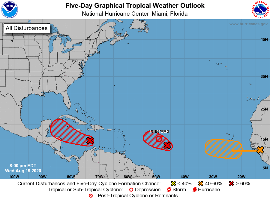
1. A tropical wave and accompanying broad area of low pressure is
producing a concentrated area of showers and thunderstorms over the
central Caribbean Sea. This system is gradually becoming better
organized, and a tropical depression is likely to form in a couple
of days when the system reaches the northwestern Caribbean Sea.
This low pressure area is moving westward, and interests in Honduras
and the Yucatan Peninsula should closely monitor its progress.
Regardless of development, this disturbance will likely produce
heavy rains across a large portion of Central America and
southeastern Mexico late this week and this weekend.
* Formation chance through 48 hours...high...70 percent.
* Formation chance through 5 days...high...80 percent.
2. Satellite images indicate that the low pressure system located about
850 miles east of the Windward Islands is gradually becoming better
defined. In addition, the associated showers and thunderstorms are
showing signs of organization, and a tropical depression could be
forming. The system is expected to move generally west-northwestward
at 15 to 20 mph, and interests in the northern Leeward Islands
should closely monitor its progress as tropical storm watches could
be required as early as this evening.
* Formation chance through 48 hours...high...90 percent.
* Formation chance through 5 days...high...90 percent.
3. A tropical wave over western Africa is producing disorganized
showers and thunderstorms. This wave is expected to move over the
far eastern tropical Atlantic on Friday, and some slow development
is possible through the weekend while it moves west-northwestward at
15 to 20 mph across the eastern tropical Atlantic.
* Formation chance through 48 hours...low...10 percent.
* Formation chance through 5 days...medium...40 percent.
Forecaster Cangialosi