ZCZC MIATWOAT ALL
TTAA00 KNHC DDHHMM
Tropical Weather Outlook
NWS National Hurricane Center Miami FL
800 PM EDT Tue Oct 8 2019
For the North Atlantic...Caribbean Sea and the Gulf of Mexico:
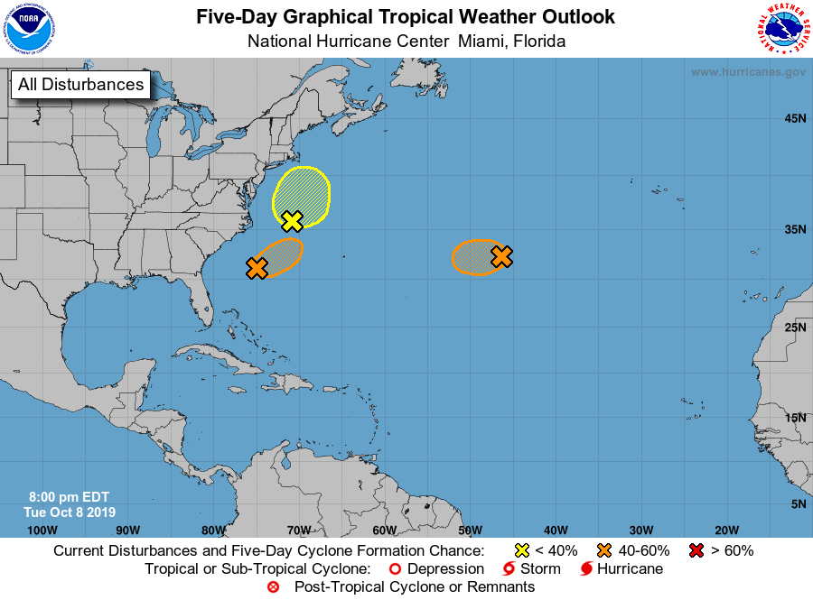
1. A non-tropical low pressure system located about 1000 miles east of
Bermuda continues to produce winds to near gale force. This system
could still become a tropical or subtropical storm while it moves
slowly westward through Wednesday. However, upper-level winds are
expected to become unfavorable for further development by Wednesday
evening. Additional information on this system can be found in High
Seas Forecasts issued by the National Weather Service.
* Formation chance through 48 hours...medium...40 percent.
* Formation chance through 5 days...medium...40 percent.
2. Cloudiness and showers located off the mid-Atlantic coast of the
United States are associated with a non-tropical area of low
pressure. This low is forecast to move northward or northeastward
and strengthen as a non-tropical low off the east coast of the
United States during the next day or so. This system could acquire
some subtropical characteristics by the end of the week while it
drifts southward offshore of the United States. Regardless of
development, this system is expected to bring strong winds, coastal
flooding, and rough surf to portions of the mid- Atlantic and
northeastern United States coasts through late week. Additional
information on this system can also be found in local products and
High Seas Forecasts issued by the National Weather Service.
* Formation chance through 48 hours...low...10 percent.
* Formation chance through 5 days...low...30 percent.
3. A small area of low pressure is located about 300 miles south of
Cape Hatteras, North Carolina. While the system is likely
producing winds to near gale force, the associated thunderstorm
activity has recently decreased. Although upper-level winds are
not particularly favorable for additional development, this system
still has the potential to become a tropical depression or storm on
Wednesday. By late Wednesday, the system is forecast to merge with
the low off the east coast of the United States.
* Formation chance through 48 hours...medium...40 percent.
* Formation chance through 5 days...medium...40 percent.
High Seas Forecasts issued by the National Weather Service
can be found under AWIPS header NFDHSFAT1, WMO header FZNT01
KWBC, and online at ocean.weather.gov/shtml/NFDHSFAT1.php
Forecaster Blake