ZCZC MIATWOAT ALL
TTAA00 KNHC DDHHMM
Tropical Weather Outlook
NWS National Hurricane Center Miami FL
200 PM EDT Fri Sep 20 2019
For the North Atlantic...Caribbean Sea and the Gulf of Mexico:
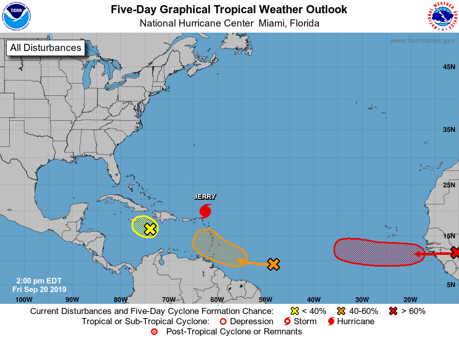
The National Hurricane Center is issuing advisories on Hurricane
Jerry, located about a hundred miles northeast of the Leeward
Islands.
1. Shower and thunderstorm activity associated with a tropical wave
located several hundred miles east of the Windward Islands has
increased during the past 24 hours. The wave is expected to head
quickly westward at about 20 mph during the next few days and will
move across the Windward Islands this weekend. Some development is
possible during that time and a tropical depression could form by
early next week. Upper-level winds are forecast to become less
conducive for development next week once the wave moves over the
eastern Caribbean Sea.
* Formation chance through 48 hours...low...30 percent.
* Formation chance through 5 days...medium...40 percent.
2. A broad area of low pressure located just south of Haiti has become
a little better defined today. However, the associated shower and
thunderstorm activity is still disorganized, and pressures in the
region are rising. Strong upper-level winds will likely prevent
significant development of this system while it moves slowly
west-northwestward for the next few days. Regardless of development,
locally heavy rainfall is likely over portions of Hispaniola,
Jamaica, and Cuba through the weekend. These heavy rains could
cause flash flooding and mudslides in areas of high terrain.
* Formation chance through 48 hours...low...10 percent.
* Formation chance through 5 days...low...10 percent.
3. A tropical wave is forecast to move off the west coast of Africa
this weekend. Environmental conditions are expected to be conducive
for development, and a tropical depression or tropical storm is
likely to form early next week while the wave moves westward across
the eastern tropical Atlantic.
* Formation chance through 48 hours...low...20 percent.
* Formation chance through 5 days...high...70 percent.
Forecaster Zelinsky