ZCZC MIATWOAT ALL
TTAA00 KNHC DDHHMM
Tropical Weather Outlook
NWS National Hurricane Center Miami FL
200 PM EDT Thu Sep 19 2019
For the North Atlantic...Caribbean Sea and the Gulf of Mexico:
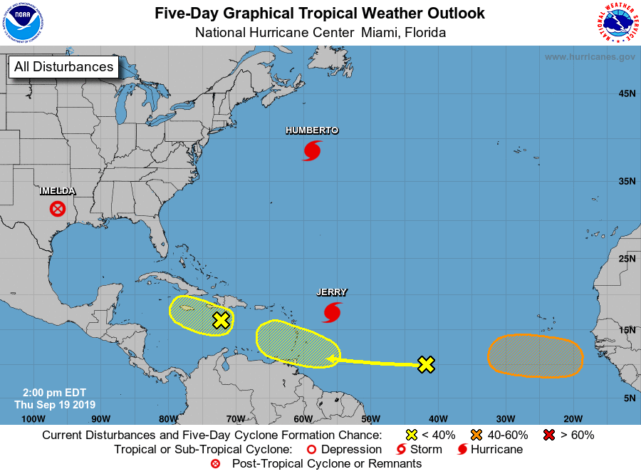
The National Hurricane Center is issuing advisories on Hurricane
Humberto, located several hundred miles northeast of Bermuda,
and on recently upgraded Hurricane Jerry, located several hundred
miles east of the Leeward Islands.
1. A tropical wave located about 1000 miles west of the Cabo Verde
Islands continues to produce disorganized cloudiness and showers.
Some development of this system is possible while the system
approaches the Windward Islands this weekend or when it moves across
the eastern Caribbean Sea early next week.
* Formation chance through 48 hours...low...10 percent.
* Formation chance through 5 days...low...30 percent.
2. An elongated area of low pressure associated with a tropical wave is
located just south of Hispaniola. Although upper-level winds are not
conducive for significant development, this system is producing
persistent showers and thunderstorms. Some slight development is
possible during the next day or two as long as the system remains
over water. Regardless of development, locally heavy rainfall is
possible over portions of the Greater Antilles during the next few
days while the disturbance moves slowly northwestward or
west-northwestward.
* Formation chance through 48 hours...low...10 percent.
* Formation chance through 5 days...low...10 percent.
3. A tropical wave is forecast to move off the west coast of Africa in
a few days. Environmental conditions are expected to be conducive
for development thereafter and a tropical depression could form
early next week while the system moves westward over the far eastern
tropical Atlantic.
* Formation chance through 48 hours...low...near 0 percent.
* Formation chance through 5 days...medium...40 percent.
Forecaster Zelinsky