ZCZC MIATWOAT ALL
TTAA00 KNHC DDHHMM
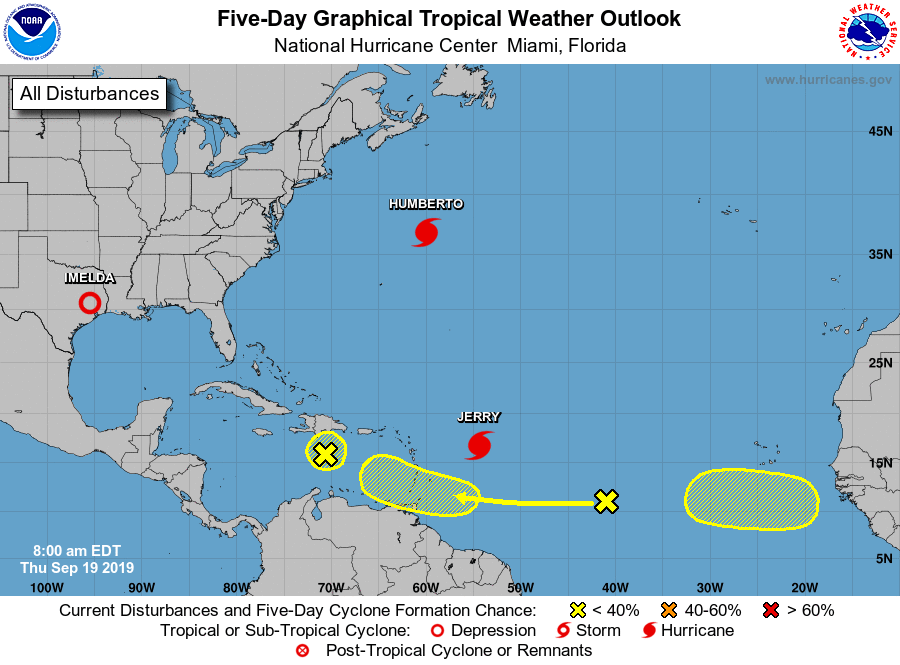
Tropical Weather Outlook
NWS National Hurricane Center Miami FL
800 AM EDT Thu Sep 19 2019
For the North Atlantic...Caribbean Sea and the Gulf of Mexico:
The National Hurricane Center is issuing advisories on Hurricane
Humberto, located several hundred miles northeast of Bermuda,
and on Tropical Storm Jerry, located several hundred miles east of
the Leeward Islands.
1. A tropical wave located about 1000 miles west of the Cabo Verde
Islands is producing disorganized cloudiness and showers. Some
development of this system is possible while the system approaches
the Windward Islands this weekend or when it moves across the
eastern Caribbean Sea early next week.
* Formation chance through 48 hours...low...near 0 percent.
* Formation chance through 5 days...low...30 percent.
2. An elongated area of low pressure associated with a tropical wave
is located just south of the Dominican Republic. Although
upper-level winds are not conducive for significant development,
thunderstorm activity has become more concentrated since yesterday.
Some slight development is still possible before the system begins
to interact with the high terrain of Hispaniola. Regardless of
development, locally heavy rainfall is possible over portions of the
Dominican Republic and Haiti during the next day or two. The
disturbance is forecast to move slowly northwestward through the
weekend.
* Formation chance through 48 hours...low...10 percent.
* Formation chance through 5 days...low...10 percent.
3. A tropical wave is forecast to move off the west coast of Africa in
a few days. Environmental conditions are expected to be conducive
for at least gradual development thereafter while the system moves
westward over the far eastern tropical Atlantic.
* Formation chance through 48 hours...low...near 0 percent.
* Formation chance through 5 days...low...20 percent.
Forecaster Zelinsky