ZCZC MIATWOAT ALL
TTAA00 KNHC DDHHMM
Tropical Weather Outlook
NWS National Hurricane Center Miami FL
800 AM EDT Fri Sep 6 2019
For the North Atlantic...Caribbean Sea and the Gulf of Mexico:
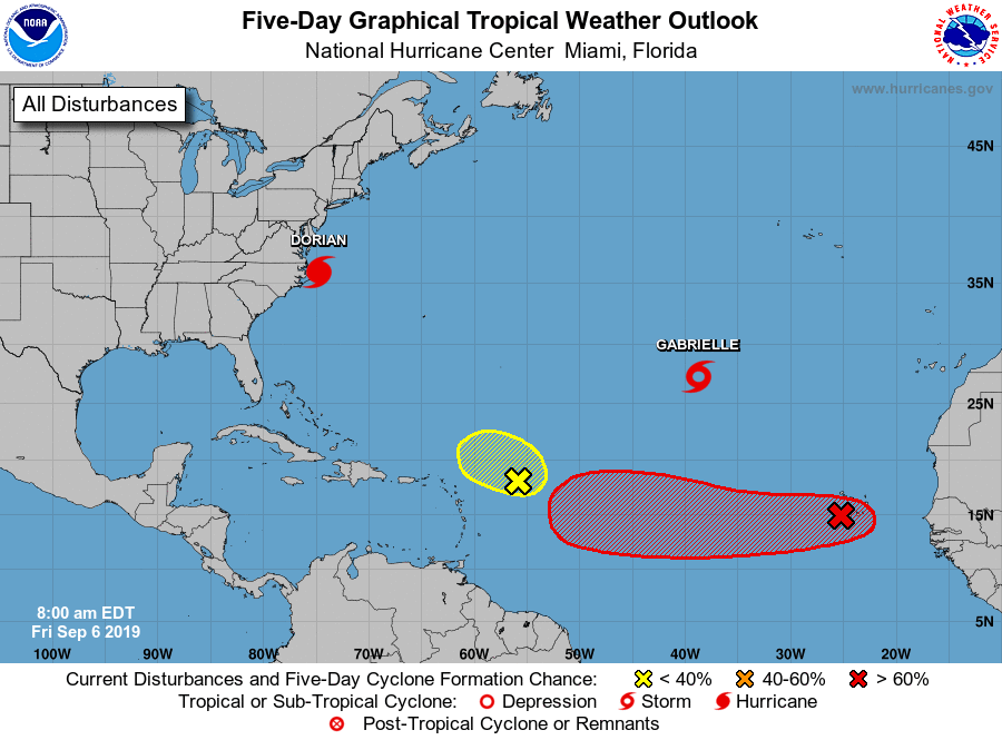
The National Hurricane Center is issuing advisories on Hurricane
Dorian, located just southwest of Cape Hatteras, North Carolina,
and has issued the last advisory on Gabrielle, which has become
a post-tropical cyclone, about 1000 miles northwest of the Cabo
Verde Islands.
1. An area of low pressure, the remnants of Gabrielle, is producing
an area of showers and thunderstorms to the north of its center.
Although upper-level winds are not particularly favorable for
re-development of this system at this time, conditions are expected
to become increasingly conducive for regeneration, and the low is
likely to become a tropical storm again within the next day or so.
* Formation chance through 48 hours...high...80 percent.
* Formation chance through 5 days...high...80 percent.
2. A low pressure system located just west of the Cabo Verde Islands
is producing a small area of disorganized showers and thunderstorms.
Little if any development of this disturbance is expected for the
next couple of days, but environmental conditions are expected to
become favorable for a tropical depression to form early next week
while the system moves westward across the tropical Atlantic Ocean.
Enhanced rainfall is possible across the Cabo Verde Islands through
today as the low moves away from the area.
* Formation chance through 48 hours...low...20 percent.
* Formation chance through 5 days...high...70 percent.
3. Disorganized showers and thunderstorms located several hundred miles
east of the Leeward Islands are associated with a tropical wave.
Development, if any, of this system will be slow to occur while it
moves slowly northwestward during the next few days.
* Formation chance through 48 hours...low...10 percent.
* Formation chance through 5 days...low...10 percent.
Forecaster Brown