ZCZC MIATWOAT ALL
TTAA00 KNHC DDHHMM
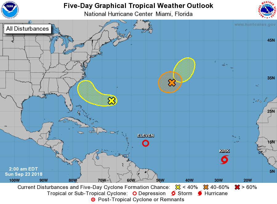
Tropical Weather Outlook
NWS National Hurricane Center Miami FL
200 AM EDT Sun Sep 23 2018
For the North Atlantic...Caribbean Sea and the Gulf of Mexico:
The National Hurricane Center is issuing advisories on Tropical
Depression Eleven, located several hundred miles east of the
Windward Islands, and on Tropical Storm Kirk, located several
hundred miles south-southwest of the Cabo Verde Islands.
1. A broad area of low pressure located about 300 miles south-southwest
of Bermuda continues to produce limited shower and thunderstorm
activity. Although strong upper-level winds currently affecting the
system are expected to diminish later today and could allow for some
development during the next couple of days, the low will continue
to be embedded in a very dry environment while it moves westward
and west-northwestward at about 10 mph over the southwestern
Atlantic Ocean. By Tuesday or Wednesday, upper-level winds are
forecast to strengthen again, likely limiting additional development
as the system turns northward and moves by the southeastern coast of
the United States.
* Formation chance through 48 hours...low...20 percent.
* Formation chance through 5 days...low...30 percent.
2. The evolution of a complex weather system over the central Atlantic
Ocean could lead to two separate episodes of subtropical or
tropical development during the upcoming week. First, a
non-tropical low pressure system currently located about 1000 miles
west-southwest of the Azores is producing gale-force winds with
some associated showers and thunderstorms. Conditions appear
conducive for this system to acquire some subtropical or tropical
characteristics during the next day or so while meandering over the
central Atlantic Ocean, and the low could become a subtropical or
tropical cyclone before it is overtaken and absorbed by a cold front
late Tuesday or Wednesday. Additional information on this system
can be found in High Seas Forecasts issued by the National Weather
Service.
* Formation chance through 48 hours...medium...60 percent.
* Formation chance through 5 days...medium...60 percent.
3. A second non-tropical low pressure system is expected to form
along the central Atlantic cold front by Wednesday several hundred
miles west of the Azores. Conditions appear conducive for this
system to also acquire subtropical or tropical characteristics by
the latter part of this week.
* Formation chance through 48 hours...low...near 0 percent.
* Formation chance through 5 days...low...30 percent.
Public Advisories on Kirk are issued under WMO header WTNT32 KNHC
and under AWIPS header MIATCPAT2. Forecast/Advisories on Kirk are
issued under WMO header WTNT22 KNHC and under AWIPS header
MIATCMAT2.
High Seas Forecasts issued by the National Weather Service can be
found under AWIPS header NFDHSFAT1, WMO header FZNT01 KWBC, and
on the Web at https://ocean.weather.gov/shtml/NFDHSFAT1.shtml.
Forecaster Berg